Minding Maine’s Middens
Project helps monitor and protect eroding cultural resources
By definition, a midden is a “refuse heap,” but in the case of a new Mitchell Center project, the heap is cultural gold and a window into Earth’s past.
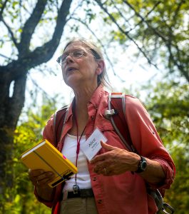
Titled “Creating a Maine Midden Minder Network and Database,” the project is being led by Alice Kelley, UMaine geoarchaeologist in the School of Earth and Climate Sciences (SECS) and associate research professor at the Climate Change Institute (CCI).
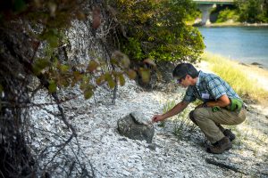
The project is focused on developing a protocol for use by volunteer citizen scientists in conservation organizations to monitor the erosion of Maine shell middens—human-created accumulations of mollusk shells, fish, mammal, and bird skeletons and artifacts such as bone and stone tools—that archive 4,000-plus years of cultural and environmental data.
The Maine Historic Preservation Commission (MHPC) has documented over 2,000 Maine shell middens. But no systematic survey of these features has occurred for more than three decades. Thus, it is currently unknown how many of the previously identified sites still exist or what their condition is. “These archaeological sites are increasingly threatened by coastal erosion, especially as sea level rises and storm intensity grows, as well as by coastal development,” Kelley says.
“Since the 1970s we have been watching and recording erosion on Maine shell middens, which has accelerated recently,” says Arthur Spiess, senior archaeologist at MHPC and one of nine stakeholders participating in the project. “The Midden Minder project will help us measure erosion more precisely, monitor more sites than we can currently, and focus our resources on sites that deserve limited archaeological digs to recover samples of information. This collaboration will be a major help to the Maine Historic Preservation Commission.”
As middens disappear, modern societies lose a link to the past. The history of ancient lifeways and associated environmental data slip beneath the waves, just as new approaches of interpreting Indigenous culture and new scientific techniques are creating innovative ways to understand human history.
Notes team member Bonnie Newsom, assistant professor of Indigenous Archaeology in the Department of Anthropology and member of the Penobscot Indian Nation, “From a tribal perspective, focusing on the middens is one way to reconnect to our heritage. European colonization broke many of our links to our past. Now, with the middens eroding, we have a natural process that is also jeopardizing those connections.”
The project will help ensure tribal involvement in the management of their archaeological heritage. Other participants will include an interdisciplinary team of students and faculty, conservation educators/stewards, and community volunteers who will participate in demonstration projects at actively eroding middens in three locations—Damariscotta, Frenchman’s Bay, and Machiasport/Pembroke.
At each of these locations, storm waves and increased freeze/thaw activity are removing the seaward-facing portion of the midden. As part of the study, the current conditions will be documented and a plan developed for repeated measurements and photography after storms and on an annual basis.
Kelley says that in the case of historic structures, such as endangered lighthouses, relocation is a costly but viable option that generally requires millions of dollars. However, in the case of shell middens this approach is not appropriate—their fragile nature means that they cannot be moved like an engineered structure. Moreover, attempts to armor middens with seawalls or riprap can create other problems, such as the erosion of beaches or adjacent properties.
““The Midden Minder project will help us measure erosion more precisely, monitor more sites than we can currently, and focus our resources on sites that deserve limited archaeological digs to recover samples of information. This collaboration will be a major help to the Maine Historic Preservation Commission.” — Arthur Spiess, senior archaeologist at MHPC
Currently, eroding sites are “saved” through careful excavation that allows digital reconstruction of the site and curation of cultural artifacts and paleoenvironmental samples. But, because of time and expense, only two to three middens are investigated each year in Maine.
“The solution this project suggests is to build a citizen-scientist network that will record changes to these sites through time, much like Maine’s well-known citizen-science efforts focused on birds, wildflowers, insects and phenology studies,” Kelley says.
She adds, “These studies, and the database they will create, will provide for culturally and scientifically informed decisions to be made as to where to focus limited funds and energy. Support from the Mitchell Center will help in developing a training protocol for conservation groups to use with their members on their properties. This is just the start of a new use of citizen science in Maine.”
Stakeholders in the effort include Acadia National Park, College of the Atlantic, Damariscotta River Association, Maine Coast Heritage Trust, Maine Historic Preservation Commission, the Passamaquoddy Tribe, the Penobscot Indian Nation, U.S. Fish and Wildlife Service, and Maine Sea Grant.
In addition to Kelley and Newsom, marine geologist Joseph Kelley of the UMaine SECS and CCI will be part of the team. The project will employ two graduate students—Kate Pontbriand (archaeologist) of CCI and SECS, and Nicholas Whiteman (geologist) of SECS—and Honors College student Anne Spezia.
All students will participate in training sessions prior to field work—with the Kelleys, Newsom, and Spiess—so that they are familiar with the scientific and cultural implications of their work.