Field Notes from Loreto
 August 2013
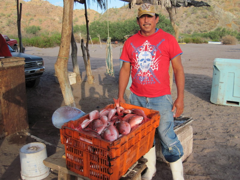
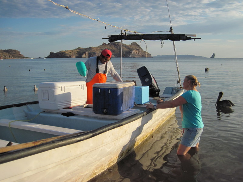
The fishermen motored into the beach at Agua Verde before first light. Most unloaded their catch of huachinango into the ice filled truck before I awoke, but I caught sight of one of the last pangas, manned by Geronimo Lara Collins, a sturdy man with a broad smile, as he and his boat mates were bringing their cratefuls of fish up to the bookkeeper to be weighed.
“Sixty-five kilos of fish, primera clase,” Geronimo noted proudly. The bookkeeper, Jose Manual Rondero, hauled the crate over to the back of the truck and tossed the fish into piles of crushed ice, to keep it cool till the truck traveled to Ciudad Constitution, the nearest market, the next day.
Geronimo’s girls, 9 and 5, appeared on the beach soon after, eager to bring him home after his night of fishing. He tarried a bit, glad for the shade of our palapa, the coffee, and the conversation. He and the other fishermen traded stories of last night’s run and adventures from times before, while I nibbled on my tortilla and fried egg. I understood much of what was said, but didn’t have the words to participate in the fluid, joke filled exchange.
I’ve spent the night on the beach in Agua Verde, the largest of El Corredor’s 13 communities and home to approximately 260 people. El Corredor is a 150 km stretch of coast between Loreto and La Paz, and is one of the most remote of Mexico’s Baja peninsula. Many of its beaches, islands, and rocky capes are only accessible by boat.
Agua Verde may also be reached by road, a harrowing one hour, one lane trip along the edges of steep cactus lined cliffs. That’s how I arrived, thanks to Amy Hudson Weaver, coordinator of the marine program for the Mexican conservation organization, Niparajá. Amy has worked in the Gulf of California region for the last 20 years, most often on marine protected areas and small-scale fisheries.
Recognizing the unique conservation value of El Corredor, Niparajá initiated a visioning process with the region’s fishing communities. While the biodiversity of the area’s marine environment is notable, the communities’ near exclusive reliance on marine resources and isolation from many institutional and financial supports traditionally provided by government also make this area uniquely vulnerable and appropriate for the region-wide, integrated approach that Niparajá has facilitated.
 Beginning in 2008, Amy and her staff went from community to community by boat, just like the fishermen, to begin conversations about the community members’ needs, interests, and hopes for the future. These conversations led to more formal surveys in 2009, to gather information on how many people live in each place, where health centers and other public services were located, where and how people fish, and ways to sustain their fishing-dependent livelihoods. After an extensive series of dialogues within and among the communities, and technical and organizing support provided by Niparajá, the communities decided to ask the federal government to create a series of fisheries refuges (zonas de refugios) to protect the habitats on which the fish and people of the region depend.
The fishermen designed the refugias based on clear criteria that reflected protected area science and practice globally: 1) The sites are ecologically important, including processes like breeding, feeding, and reproduction; 2) The sites are actively fished; and 3) The sites are enforceable and the fishermen are committed to complying with the regulations. This last criterion eliminated many possible sites of high ecological value; if the fishermen themselves would be unable to monitor activities within the refugia and ensure that they were in fact protected, they were eliminated from consideration.
Whether you classify the effort to be ecosystem-based fisheries management, marine spatial planning or something else, what is striking to me is the goal of protecting ecologically and economically important places within the seascape of El Corredor, in order to sustain the fisheries on which the communities depend. The fishermen and Niparajá have focused almost singularly on one activity – fishing – because that’s essentially the only way that people are directly linked to the ecosystem on this remote coast. There is little land-based pollution, the communities are very small; nor coastal development, beyond the palapas that shade the fishermen in off hours. Depending on your view, this situation is either good fortune or a challenge or both.
The process of designing and declaring the refugias has taken several years, and depending on who is telling the story, is far from over. While Mexico’s federal fisheries and environment agencies declared the sites through a secretarial agreement last November, the government has since been reticent to provide needed political support and resources, and also has faced challenges from the state government, which is dominated by a different political party.
After Geronimo and his girls headed home, I spoke with another of the fishermen, Jesus Firmato Leon. After the night of fishing, he talked proudly of the zonas de refugias pesqueros that the fishermen had worked so tirelessly to establish. Drawing the coastline in the sand, he showed me where the closest refugia is located. He talked about how it protects the fish and whole ecosystem, particularly from gillnets (chinchorros) and industrial scale shrimp boats. “This is important,” Jesus concluded.
The challenge now is to maintain the momentum that the communities and their supporters have generated in the last several years, and to ensure the refugias are enforced. Then they will need to be monitored, in order to assess the ecological and institutional impacts and to guide future action. The refugias have a sunset of 5 years, which means that there is a clear opportunity to improve on the original design and to take stock of what the impacts have been.
Five years is a really short time period, both for evaluating protected area efficacy as well as for more complex ecosystem-based strategies, such as the capacity building and community organizing that have been cornerstones of Niparajá’s conservation strategy in the region. Yet we know from our own and others’ investigations of ecosystem-based planning and implementation, on the scale of three to five years, there are often intermediate changes in local institutions and ecosystems, such as increase in community cohesion, changes in the timing and spatial distribution of fishing, or improvements in the condition of target species and habitats. Such signs of progress often precede the ultimate management outcomes objectives – healthy communities and healthy ocean ecosystems – by many years. Thus keeping track of such indicators is vital in order to assess progress and guide adaptive management.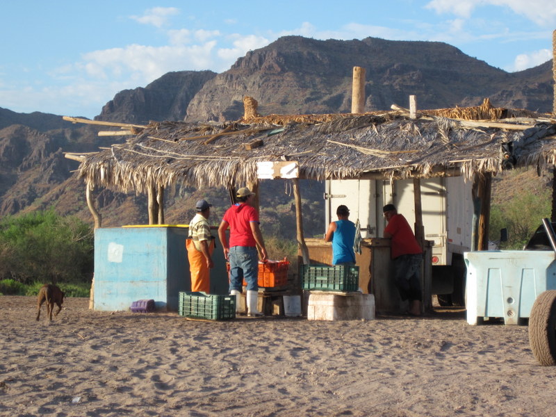
After my visit to Agua Verde, I’m convinced more than ever of the importance of integrating conservation strategies across local, regional and national scales in ways that benefit both nature and people. The protected areas of El Corredor wouldn’t have been declared without a concerted effort at these different institutional and geographic scales, and their ultimate success, I wager, will likely depend on continued efforts that span these levels.
Heather Leslie is a marine conservation scientist and Libra associate professor at the University of Maine’s School of Marine Sciences. When she wrote this post, she was an assistant professor at Brown University in Providence, RI.