
IAT International Appalachian Trail
Itinerary Note
While we have researched this International Appalachian Trail, we are not sure whether it is feasible to actually hike on it without first contacting border control. You will definitely need to have your passport with you since the trail is on the border of the US and Canada
Did you know that there is an International Appalachian trail?
“The International Appalachian Trail (IAT) began as a commitment between the U.S. state of Maine and Provincial Canada to work together as neighbors to sustain a shared environment and celebrate the grandeur of a common landscape. In North America the trail connects elements of the Appalachian Mountains, crossing rivers, threading open spruce and fir forests, joining the people and cultures of Maine, Quebec, and Atlantic Canada. Since 2009, this mission has been embraced in Greenland and Iceland and across the arc of the North Atlantic to Europe and North Africa. The IAT now comprises 23 Chapters on three continents from Maine to Morocco. Progress to maintain and improve the trail experience continues in work with landowners, hikers, conservation organizations, and local, regional and national governments.”
People travel the world to hike this beautiful trail, but you can hike it right here in Maine!
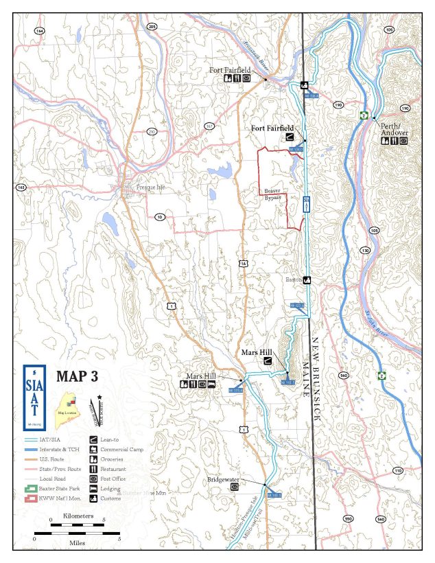
Directions from Mars Hill to Fort Fairfield
“IAT-SIA Official Route — Town of Mars Hill to the International Border Trail
This section from Mars Hill to the Border Trail is 8.2 miles long and includes a hill climb, an IAT lean-to, a traverse of a wind farm, and a short road walk.
115.4 Multi-use trail junction with Route 1A in the town of Mars Hill. Follow Route 1A north to Boynton Road.
115.8 Turn right (east) on Boynton Road, heading towards Mars Hill Mountain.
117.1 Turn right (south) onto East Blaine Road. (Note: To reach the international border trail without climbing Mars Hill, turn left (north) and follow the East Blaine Road approximately 4.5 miles.)
117.3 Turn left (east) onto Graves Road and follow it into the Mars Hill (BigRock Mountain) Ski Area. Head towards the south end of parking lot after entering the Ski Area. (Note: There is another trail to the left, in
front of the lodge, but this trail is not recommended).
117.6 From the south end of parking lot, go right and follow the access road leading up the mountain that starts
near the ski lift. Climb the mountain starting at the transformer pad at the bottom of the lift and follow
the marked trail.
117.9 Turn right (south) and walk between two ponds.
118.0 At the chairlift again, turn left (east) and start up the trail. The trail switchbacks in and out of the north side of the ski trail, until it veers to the right near the top of the mountain.
Mars Hill, Maine: Post Office (04758) 207.429.9177, Banks with ATM, IGA Supermarket, Mars Hill Pharmacy. Restaurants: Mobil Station with Subway; House of Pizza; Al’s Diner; Mars Hill Dairy Bar; Laundromat; Bear Paw Inn, 207.425.6241, www.mainebearpawinn.com (0.1 mile off-trail).
NOTE: Mars Hill lean-to and campsite: Email Dave Grant (dgrant@sunedison.com) or call the Wind Farm (207.425.7929) in advance of camping so the company knows who is on its premises. There is no water at the shelter site. Water must be brought from the town or taken from the small pond at the base of the hill and treated.
When entering a tower pad, stay clear of the tower. Head to or from the access road. Trail entrances/exits are marked with flagging tapes on a tree or bush. IAT-SIA tags will be on trees every so often. Some of the tower pads have a number marking on a small stake. There is a small tower number above the door of each tower.
NOTE: Hikers must call the U.S. Border Patrol in Fort Fairfield, 207.472.5041 before walking on the border clearing trail and say when they will be hiking there. Hikers must stay inside the cleared area of the border until crossing into New Brunswick. A valid passport is required for all hikers entering either Canada or the United States. Hikers planning to enter Canada must use the ArriveCAN mobile app or website to provide mandatory travel information 72 hours prior to their arrival in Canada. Visit: cbsa-asfc.gc.ca/menu-eng for more details. 2022 Maine IAT Trail Guide 7/30/2022 12
118.5 At the top, the trail intersects an old ATV trail. The Mars Hill lean-to is 0.2 miles to the right (south). Turn left (north) to follow the trail to the Wind Farm Access Road and along the ridge of Mars Hill. (Note: To see all the towers, walk past the lean-to and continue toward the nearby Tower (#27). There is a trail down a
slope to the Tower pad. There is only one other tower to the south (Tower #28)).
118.7 Reach the top of the ski area chair lift near Tower #25. The Wind Farm Access Road is to the right through a gate in a chain link fence. Follow the access road north past several towers and over a couple of hills.
112.0 A service road enters from the left near Tower #17. Stay to the right-hand road; walk less than a mile past six more towers up a hill. Continue around the hill passing Towers #12 and #11. From this road, two TV/Cell towers can be seen higher up to the left.
120.8 Stay to the left, leaving the main access road, and hike up towards Tower #10.
120.9 Reach the edge of the woods, just beyond and to the left of the pad for Tower 10. Flagging tape marks the trail’s entrance into the woods. Tower #9 can be seen straight below, and there is a great view to the north.
121.8 Trail exits woods near the pad for Tower #8. From the pad, walk to the access road and turn left onto the North Access Road. Continue down the North Access Road to Tower #6.
122.1 Just beyond Tower #6, the trail leaves the North Access Road to the right (east) and enters the words. Look for blue flagging tape marking the location.
122.5 After passing near Towers #5 and 4 (which can be seen to the left), the trail turns east and joins an old farm road. Continue north on this road. The trail enters a large field and follows the tree line. (Note: Hikers may optionally stay on the North Access Road, which intersects the East Ridge Road in 0.7 miles. The trail joins the East Ridge Road 0.2 miles east of this intersection.)
122.8 Trail reaches the East Ridge Road. Turn right (east) on this road and walk towards the U.S./Canada border.
123.6 Reach the U.S./Canadian border. Turn left (north) onto the cleared strip of land, the “Border Trail”.
IAT-SIA Official Route — International Border Trail to Fort Fairfield Section This section is 14.8 miles long and includes the clearing along the border, the skirting of a beaver pond, an IAT lean-to, the Sam Everett Road and Route 127 (an alternate route continues on the border trail to the border).
123.6 From the East Ridge Road at the U.S./Canadian border, turn left (north) onto the cleared strip of land and follow the “Border Trail”.
125.8 Reach the Easton US customs border station (if open, hikers may obtain drinking water at the station) and cross the River de Chute (water source) just north of the station. If the water is low enough, you may cross on rocks, but may get your feet wet if the water is too high for rock hopping. Continue on the
Border Trail over rolling hills with wonderful views of Aroostook County farmland.
129.4 Pass the Curtis Road. A large gate blocks the road on the Canadian side.
130.3 Reach the southern beaver pond. As you approach the pond from the south, look for the ByPass Trail flagged with blue tape to the west.
ByPass Trail (NoBo)
300 ft Trail reaches south side of old beaver flowage meadow. 700 ft Trail reaches north side of old flowage and joins faint, old woods road.
1200 ft Trail crosses old culvert in streambed.
1500 ft Trail leaves old woods road and heads northeast, passing old beaver pond.
2000 ft Trail enters cedar swamp. Footing is wet in places.
2600 ft Trail crosses small brook. Hikers can log hop to keep their feet dry.
3000 ft Trail turns northeast and climbs to Border swath.
130.9 Bypass Trail rejoins Border swath.
132.2 Trail passes Dorsey Rd to the west.
134.0 Reach the Fort Fairfield lean-to and campsite. Note: Hikers using the Fort Fairfield lean-to and campsite are only allowed to use a cook stove. Open fires are not allowed. Water is available at the nearby brook, west of the lean-to.
134.4 Trail turns left (west) onto the Sam Everett Road. Hikers may continue north on the Border Trail for 2.7 miles directly to Fort Fairfield and the Canadian Border Station. Although this alternate route is 1.1 miles shorter, it can be quite wet in places.
137.5 Sam Everett Road reaches Route 167. Turn right (east) and follow the road to the U.S./Canadian border.
138.4 Reach the International Border! After crossing the border into Canada follow the New Brunswick Trail
Guide. Note see page four regarding where to find current border crossing requirements online.
Fort Fairfield, Maine: Post Office (04742) 207.476.6021. This is the last U.S. town before crossing the border into New Brunswick. Services: IGA; Irving Mainway; Banks; Taxi-Aroostook Cab Co., 207.764.1600
Customs: North-bound hikers check in on the Canadian side; south-bound hikers check in on the US side.”
https://www.maineiat.org/wp-content/uploads/2023/09/MaineIAT_Route_Description_with_Maps_07_2022.pdf
Access to the IAT in Fort Fairfield
Directions: “There is a trailhead located at the end of Sam Everett Road in Fort Fairfield for people interested in hiking this scenic section of the trail (NOTE: Hikers must call the U.S. Border Patrol in Fort Fairfield, 207.472.5041 before walking on the border clearing trail and say when they will be hiking there. Hikers must stay inside the cleared area of the border until crossing into New Brunswick. A valid passport is required for all hikers entering either Canada or the United States).
For thru-hikers, Fort Fairfield offers a host of services including a grocery store, restaurants, drug store, banks, laundry mat, and health clinics a short distance from the trail. Currently, there are no lodging accomodations available in Fort Fairfield, but there is a lean-to available for overnight use along the Fort Fairfield section of the trail (at mile 134 north from Baxter State Park). No fires are allowed at the campsite.”
Fun Facts
“The Appalachian Mountains
The Appalachian-Caledonian Mountains were formed more than 250 Million years ago during the Paleozoic Era, when the earth’s plates collided to form the supercontinent Pangea. They straddled the central part of that continent in what is today eastern North America, eastern Greenland, western Europe, and northwest Africa. When Pangea separated to form the Atlantic Ocean, remnants of the Appalachian-Caledonian Mountains ended up in the eastern United States and Canada, Greenland, Scandinavia, the British Isles, Brittany, the Iberian Peninsula, and the Anti-Atlas Mountains of Morocco.” https://iat-sia.org/about/
“In Maine, the IAT/SIA starts in Katahdin Woods & Waters National Monument in the U.S. State of Maine. The trail heads northeast along the East Branch of the Penobscot River and then east towards Mount Chase and, eventually, Houlton. At Houlton, the trail turns north again and continues to Mars Hill Mountain in Aroostook County. It follows the United States/Canadian international border northward to Fort Fairfield where it crosses into Perth-Andover, New Brunswick.
In New Brunswick, the trail accompanies the Tobique River through the village of Plaster Rock to Mount Carleton and on to St. Quentin, Kedgewick and the Upsalquitch Valley, crossing the Restigouche River into Québec at Flatlands, New Brunswick.
In Québec, the trail leaves Matapedia and proceeds to Amqui then through the Reserve Faunique de Matane to Mount Logan in the western portion of the Parc de la Gaspésie. The trail then turns eastward to Mont Albert, Mont Jacques Cartier, and the legendary cliffs of Cap Gaspé in Forillon National Park.
On Prince Edward Island, the trail begins at the Confederation Bridge in Borden, travelling northeast to the center of the island and then turning east to Mt Stewart. Here, the trail heads south to the ferry at Wood Islands.
In Nova Scotia, the trail picks up at the Ferry Terminal in Caribou, NS and meanders along the coast of Northumberland Strait to the Canso Causeway where it crosses to Cape Breton Island. On Cape Breton, the trail continues mostly along the coast to Inverness, where it turns inland, threading between the Bras d’Or Lakes and then heading to the North Sydney Ferry Terminal.
After crossing the Gulf of St. Lawrence by ferry, the trail resumes in Port-aux-Basques, Newfoundland, heading northeast along the Long Range Mountains. Adventurous hikers can explore numerous side trails into extremely remote and scenic areas such as the Lewis Hills and Gros Morne National Park. The Newfoundland/Labrador section of the trail ends at L’Anse aux Meadows National Historic Site.”
Activity Alternatives

Hotel Alternatives
Restaurant Alternatives

Packing Checklist
The weather in Maine can be unpredictable. Therefore, here are some ideas to be prepared. Wear comfortable clothes and dress in layers, Maine is very casual, so you probably will not find any restaurants that require formal attire.
Spring/Summer/Fall: clothes, comfortable sneakers or hiking shoes for walking, sun hat, sunscreen, sweater or jacket, insect repellent, toiletries, and phone/camera
Winter: clothes (layers), ski pants highly recommended, winter boots, jacket, hats, scarves, gloves, warm socks, toiletries, and phone/camera. Please pack a helmet if you are participating in snowmobiling, skiing, or snowboarding.