Sasquatch River Trail

Can you spot a Sasquatch along the Aroostook River?
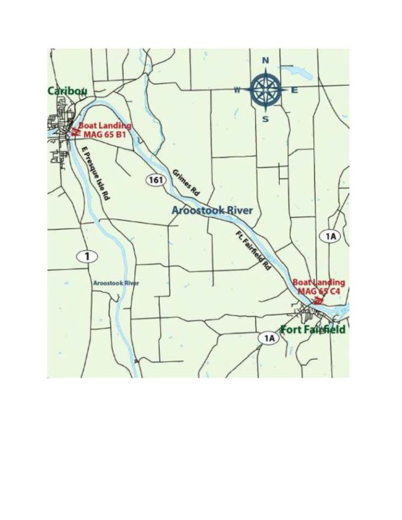
This paddle trip has 3 options:
- For the hard-core serious paddler, the entire 14- mile trip from Caribou to Fort Fairfield is an all-day trip:
- “PUT-IN AT CARIBOU, CARIBOU STREAM
Heading north on US-1, go 260 feet north of the junction of US-1 and ME-161 (Fort Street) in Caribou and turn right onto Lower Washington Street. Go 485 feet to its end and turn left onto Lower Lyndon Street. Go 500 feet to where Lower Lyndon Street bends to the left, and turn right to the boat launch. Located a half mile downstream of the dam, this access is paved and has good parking.”
- “PUT-IN AT CARIBOU, CARIBOU STREAM
- FORBES PIT BOAT LAUNCH
“For a shorter trip, an alternative access point is a hand-carry launch near the Caribou/Fort Fairfield town line. It is located 4.9 miles west on ME-161 from the junction with US-1 in the center of Caribou. Known locally as the Forbes Pit Boat Launch, the site has ample parking.”- Note- this boat launch area requires you to carry your boat down a small narrow hill. We strongly recommend that you wear water shoes!
- Put in at the Caribou boat launch and take out at the Forbes Pit boat launch.
Fort Fairfield take-out area: “After passing under the US-1A bridge in Fort Fairfield, keep an eye out for the take-out on the left (north) just past the bridge, with a paved launch and dock.”
Note- for any of these options, you will need to have a car at your final destination to bring you back to where you started.
From: https://www.mainetrailfinder.com/trails/trail/aroostook-river-paddling-route-caribou-to-fort-fairfield
“This trip is great for beginning paddlers, with mostly gentle water and a few easy rips. This segment of the river winds through a mix of rural forests and farmland. At times, the channel is very close to the river banks. Canoeing is possible in the spring and early summer, and kayaking possible during the summer months. Good brook trout fishing can be had early in the season. The river here parallels ME-161, but it is still a scenic trip.
From the upper launch just below the dam, the Aroostook flows northeast for 1.5 miles before turning east and then southeast. Passable by kayak in most conditions, the upper section of this stretch may require dragging for canoeists low water. At the islands at 3.3 miles into the route, run along the right bank to avoid grounding in the riffles in mid-stream and river left.”
And be sure to watch for Sasquatch in the woods!!
Can you spot a Sasquatch?


Here is a more detailed description and map of the route from https://viewer.joomag.com/northern-maine-water-trail-map-guide-act-2018-water-trails/0558482001529092376


