NCGIA Research Areas
NCGIA conducted research in the areas of spatio-temporal reasoning, spatio-temporal modeling, sensor informatics, geosensor networks, spatial cognition, human-computer interactions, and geographic information science policy issues.
- Indoor Spaces and Indoor Navigation
- Spatio-Temporal Data Models
- GeoSemantic Web
- Location Privacy
- Geosensor Networks
- Human Computer Interaction and Spatial Cognition
Indoor Spaces and Indoor Navigation
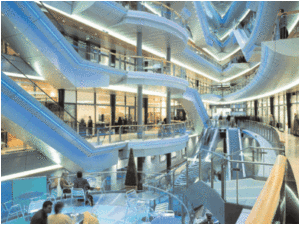 Researchers in NCGIA investigated theories and representations for indoor spaces and support for navigation in indoor spaces. Theories for indoor spaces consider the behavior of indoor spatial objects and characteristics of indoor spaces that are distinct from outdoor space. Navigation in outdoor space has come to rely heavily on GPS but no single technology similarly supports indoor navigation. NCGIA research investigated support for indoor navigation strategies and seamless transitions from outdoor to indoor space.
Applications for indoor models and navigation include:
- Resource location/allocation
- Crowd management
- Emergency services
- Navigation aids for low vision or blind persons
Spatio-Temporal Data Models
 New data acquisition technologies including sensor systems are generating information with much higher spatial and temporal resolutions. Such data opens great potential but also new challenges for representing dynamic aspects of phenomena and drives the need for new models that support combined spatial and temporal dimensions.
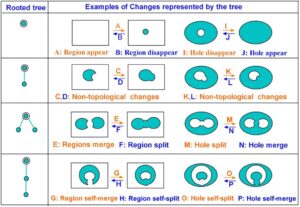
NCGIA investigated conceptual and logical models for spatio-temporal processes, development of event models, and models of change (e.g topological change models). Such models have application for modeling many dynamic processes including oceanographic events, emergency response situations, health and epidemiological events, and climate change.
GeoSemantic Web
The vision for the Semantic Web is to enhance information retrieval by incorporating semantics and exploiting the semantics during the search process. Such developments need special attention from the geospatial perspective so that geospatial meanings are captured appropriately.
The Geospatial Semantic Web research involved developing multiple spatial and terminological ontologies, each with a formal semantics; representing those semantics for both machine processing and human understanding; and enhancing geospatial queries based on ontologies.
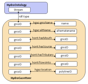 Figure 1 (left): Example of HydroOntology represented as rdf model (Resource Description Framework) that links a water body type (Stream) with its HydroGazetteer schema which includes: attribute properties (Name, AltName), its connectivity properties (Mouth, Source, Tributary), topological properties (FlowsInto) and location properties (Location).
Location Privacy
 New and expanding spatial, mobile and context-aware technologies, coordinated spatial data infrastructures and sensor-networks are making it easy to acquire and merge information on the geographic locations and movements of individuals with potentially profound implications for personal information privacy. Location privacy concerns the protection of individual rights against unwanted tracking of their movements and collection and dissemination of such information for purposes of profiling. Research considers the potential effects on spatial technology uses and development of legal and technological approaches for the protection of personal information privacy. Professor Harlan Onsrud was a lead researcher in investigating legal and ethical implications of new information technologies.
Proscriptive Strategies
- Regulatory Strategies
- Establish and enforce rules for fair use of location information
- Privacy Policies
- Annotate location with specification of acceptable use
Information Hiding Strategies
- Obfuscation
- Deliberately degrade location information quality
- Anonymity
- Dissociate identity from location
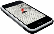
Geosensor Networks
 NGCIA advanced research is the area of sensor informatics and geosensor networks. Geosensor networks monitor phenomena in geographic space. The extent of the geographic space can be as small as a room or as large as an ecosystem. These sensors can be static or mobile, and can be used to passively collect information about the environment or to actively influence it.
The research challenges in sensor informatics and geosensor networks extend the frontiers of traditional GIS research to issues like data stream processing, mobile computing, location-based services, temporal-spatial queries over geosensor networks, adaptable middleware, sensor data integration and mining, automated updating of geospatial databases.
For more information visit Geo-Sensor Networks.
Human Computer Interaction and Spatial Cognition
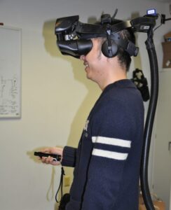 As devices get smaller, even become invisible and are everywhere in the environment, we need new interaction modes. To accommodate different users in different contexts there is a need for multimodal interactions. Research at NCGIA has developed several novel interaction modes including sketching and pointing.
Different modalities are also needed when different sensory channels are limited or inappropriate for a task or setting. NCGIA research investigated human spatial cognition, information requirements for the design of multimodal interfaces, and usability studies on interaction technologies.