Citizen update streams can inform creation of real-time natural disaster map, researchers find
Social media posts during a natural disaster can provide a data stream to inform mapping of the event in real time, according to a new University of Maine study from the School of Computing and Information Science.
People located close to events such as flooding, wildfires and mudslides can provide a stream of current data through posts reflecting their responses to the event. Data from many people can contribute to an integrated spatiotemporal map to provide a comprehensive look at the event.
The research, led by Iranga Subasinghe, a Ph.D. student in spatial information science and engineering; and Silvia Nittel, associate professor in spatial informatics; focused on whether information from citizens affected by a natural disaster is enough to generate a map of the event as it unfolds.
Social media posts are usually text-based, the researchers note, and contain natural language from real people. This study makes empirical sense of that qualitative data to provide useful, reliable information to citizens.
“To the best of our knowledge, this article is the first work that investigates spatiotemporal social media stream processing to map an unfolding natural disaster in real time,” the researchers write.
The study, “Real-time mapping of natural disasters using citizen update streams,” aligns with the University of Maine System “Research and Development Plan.” It was published in the International Journal of Geographical Information Science.
Specifically, the research question was how the degree of citizen participation affects the quality of mapping an event.
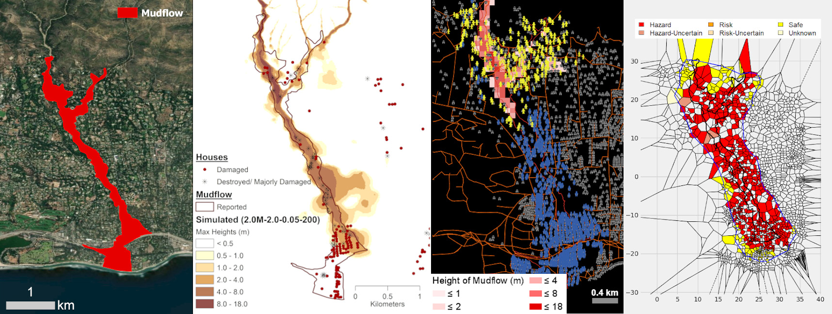
The research team created a Citizen Disaster Reaction Multi-Agent Simulation (CDR-MAS), which replicates the reaction of citizens to a natural disaster in an urban region, and used it to simulate reactions to the 2018 Montecito Creek mudslide in California. This experiment included creating a detailed, realistic modeling of the mudslide behavior using a Swiss rapid mass movement stimulation tool.

The research team used the simulations to evaluate the feasibility of using citizen-generated data update streams to create a visualization of a natural disaster as it develops, exploring the effects of different parameters — percentage of citizen participation and percentage of citizen movement.
By measuring two parameters — event boundary and event region — they found the amount of citizen participation and movement significantly influenced event mapping. Event boundary is the outside boundary or the spatial reach of the event itself, and event region shows the “inside” of the event that is the destruction caused by the event over the region it covered.
“The results demonstrate that the accuracy of the boundary match is in most cases above 46% if at least 40% participation is available,” according to the researchers. “This shows that even with a lower participation percentage such as 40%, the boundary of the event is adequately predicted, independently of how many people move during the disaster.”
The accuracy of the region match also depends significantly on the participation degree. The entire disaster region is predicted within at least 39% accuracy when participation is 40%. With 20% participation or less, the accuracy is between 7 and 22% depending on citizen movement, according to the study.
“Overall, our results show that the event representation is a buffer zone around the event rather than the boundary of the event itself,” say the researchers. “The ability to map an event depends significantly on citizen participation, as expected.”
With effective levels of citizen participation, this mapping method has the potential to help inform and warn people during a natural disaster as it develops.
Other UMaine researchers involved in the study are Michael Cressey, a spatial information science and engineering master’s student; Melissa Landon, then an associate professor of civil and environmental engineering and now a senior project engineer with Golder Associates, Inc.; and Prashanta Bajracharya, a civil and environmental engineering master’s student.
The study was supported by the National Science Foundation.
Contact: Cleo Barker, 207.581.3729
