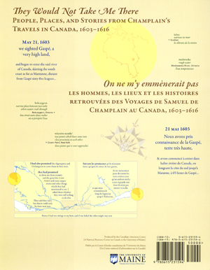
Champlain Map: “They Would Not Take Me There”


Award-winning EXPLANATORY MAP produced by the Canadian-American Center, illustrates the travels of Samuel de Champlain as he explored what is now Canada, seeking a route between the St. Lawrence River and James Bay.
Authors/Cartographers: Michael James Hermann & Margaret Wickens Pearce
Translator: Raymond Pelletier
- Description
- Specifications
- Reading the Map: image of entire map
- How the Cartographers Made the Map
- Cartographers’ Use of Color
- Links to Publicity
- Bibliography of Native Place Names
This map, produced by the Canadian-American Center, illustrates the travels of Samuel de Champlain as he explored Canada between 1603 and 1616. During those thirteen years, Champlain made seven trips into the interior, forging trade alliances with multiple First Nations, accompanying them in their wars against the Iroquois, building Québec, and collecting geographic information for his maps and journals. These travels were dependent on the knowledge, skills, and technologies of the Algonquin, Wendat, Wabanaki, and Innu which formed the basis for his published journals, Les Savauges and Les Voyages.
Although Champlain’s attention encompassed a range of economic, religious, and colonial interests, his written accounts suggest a personal passion for finding the connection between the St. Lawrence River and what is now James Bay. Drawing on Biggar’s edition of Champlain’s journals (The Works of Samuel de Champlain, H.P. Biggar, ed. 1922-36), Trigger’s ethnohistorical Huron study, (The Children of Aataentsic: A History of the Huron People to 1660, Bruce G. Trigger, 1987), and numerous linguistic and geographical references, this cartographic work weaves together Native and non-Native experiences, negotiations, and strategies in the years before the creation of Québec City and New France.
The Cartographers’ Voices :
“At one level, Champlain’s explorations have been extensively documented and mapped by scholars focusing on the locations and dates of Champlain’s arrivals and departures. But these maps are silent with regard to the Indigenous geographies through which Champlain moved and upon which he relied for the success of his own explorations and mappings. Also, they fail to convey the human experiences which shape the emotional geographies of his journals.”
– MWPearce and MJHermann
English on one side:
They Would Not Take Me There; People, Places and Stories from Champlain’s Travels in Canada, 1603-1616
Français de l’autre côté:
Les hommes, les lieux, et les histoires retrouvées des Voyages de Samuel de Champlain au Canada, 1603-1616
Measurements:
Flat: 39 x 59 inches
Folded: 8 x 10 inches
Available rolled or folded
ISBN 978-0615-23159-4
Publisher:
The University of Maine
Canadian–American Center
Orono, Maine, USA
Price (US):
Retail: $14.99
Educational use: $10.00
Plus postage