Forecast of particle transport in the region surrounding Mount Desert Island
As our climate changes and coastal areas become more populated, we will undoubtedly face new and worsening challenges in our coastal environments. The water quality of estuaries and bays along our coastlines depends on the ability of these systems to transport and flush water-borne material in an efficient and timely manner. Some materials in particular that are problematic for our coastline include harmful algal blooms (HABs), microplastics, and bacterial pollution. What materials like these have in common is that their abundance in a particular region depends on the circulation patterns of the water. However, in regions where the flow interacts with complex topographic features, such as islands, headlands, channel constrictions, and bathymetric variations, these circulation patterns become very complex. In order to predict how material is transported, we must first understand and be able to replicate how complex coastal features can impact local circulation patterns. Numerical hydrodynamic models, which solve theoretical equations to estimate the motion of water, are incredibly powerful tools that we can use to better understand circulation patterns, and ultimately material transport.
Frenchman Bay, Maine, with its numerous estuaries, islands, and extensive tidal flats, is an exemplary complex coastal system presently facing environmental challenges. In recent years, regionally novel species of harmful algal blooms (HABs) have been detected in Frenchman Bay (personal communication with the MEDMR) and elsewhere in the Gulf of Maine (Bates et al. 2018). HABs are fast-growing algae that can produce toxins under some conditions. When people consume animals like shellfish that feed on these algae, it can lead to illness. For this reason, toxic HABs force the Maine Department of Marine Resources (MEDMR) to make extensive closures of coastal zones to aquaculture farming and shellfish harvesting to ensure public health and safety. Frenchman Bay’s aquaculture, fishing and shellfish harvesting industries are a major source of revenue for the state of Maine, and these closures threaten the economic stability of those industries and the wellbeing of those who rely on them.
While we are still learning about the conditions that lead to the initiation and growth of HABs, like all water-borne material, the transport of HABs in coastal waters depends on the local hydrodynamics. By improving our understanding of the transport of water-borne materials in complex regions like Frenchman Bay, we can begin to refine the monitoring and management practices surrounding these blooms.
As a first step, our team has developed a three-day forecast of “particle” transport in Frenchman Bay. This video forecast provides a tool for informing where material might go in the bay depending on conditions that influence the regional circulation patterns including winds, tides, salinity, and streamflow. Our forecast encompasses the region around Mount Desert Island, home to Acadia National Park.
Forecast animation
The video above shows the current day and 48 hours before and after. The line plot above the map depicts the water level over this time period. The color of the map corresponds to the depth-averaged current speed with arrows showing the direction of the currents. The colored circles represent different “particles” which mimic how a parcel of water moves with the currents. The particles serve as a proxy for material transport in the region. The X and Y coordinates on the map are Universal Transverse Mercator (UTM) coordinates which represent eastings (X) and northings (Y) in UTM zone 19 (see this USGS page [external link] for more details on the UTM coordinate system). Eastings represent distance measured from the central meridian of the UTM zone, and northings represent distance measured to the north from the equator.
A note of caution on the interpretation of the animation results:
While animations like ours developed from numerical simulations can be invaluable tools for learning about circulation patterns and material transport, the results should be interpreted with caution. In addition to the assumptions made in the theory used for the development of the model software (see here to learn more about TELEMAC-2D [external link]), there are several elements of this animation which warrant discretion in the interpretation of its results. The numerical model used to develop the animation shown above is the TELEMAC-MASCARET two-dimensional (TELEMAC-2D) model. TELEMAC-2D is a depth-averaged hydrodynamic model (see About the model), and therefore the circulation patterns depicted in our animation represent an average of the currents over the entire water column. Secondly, no biological processes (e.g. growth, decay, vertical migration, etc.) are incorporated in the modeling of the particles, so care should be taken when extrapolating these results to real biological phenomena. Lastly, the model validation focused primarily in the waters on the northeastern side of Mount Desert Island. This page details the model validation. In addition to these notes, please see About the model below to learn more about the assumptions and uncertainties involved in the external data used to force the model.
About the model:
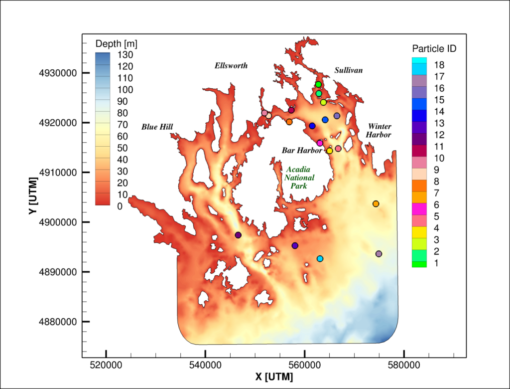
This animation was created from a TELEMAC-2D numerical model simulation. The full model domain showing the bathymetry of the region is shown below. The model bathymetry is from from National Oceanic and Atmospheric Administration (NOAA) bathymetric survey data (maps.ngdc.noaa.gov), with a resolution up to 30 m. The “particles” are modeled as passive (i.e. they do not affect the flow) and neutrally buoyant (i.e. they move with the currents). The model is run with a 10 second numerical timestep and results are output hourly.

This model is forced by tides, freshwater streamflow, salinity at the ocean boundary, and wind. The ocean boundary is forced by regional astronomical tidal currents and water level elevations comes from the TPXO Global Tidal Solutions (www.tpxo.net/global) and a three-hourly time-series of salinity data obtained from the HYbrid Coordinate Ocean Model (HYCOM; www.hycom.org/). Streamflow is included at 17 river boundaries in the model domain, where tributaries discharge freshwater into the region. Three-hourly streamflow data from the National Water Model (water.noaa.gov/about/nwm) are used to force the model during the five-days of the simulation shown in the animation. To ensure the stability of the model, a minimum streamflow of 0.1 m3/s is imposed at all boundaries during the simulation. Wind forcing is included at several locations in the domain at three-hourly timesteps using wind speed and direction from the National Digital Forecast Database (NDFD) model (vlab.noaa.gov/web/mdl/ndfd). The model is continually run on the ACG Cluster.
References
Bates, S. S., Hubbard, K. A., Lundholm, N., Montresor, M., Leaw, C. P. (2018). Pseudo-nitzschia, Nitzschia, and domoic acid: New research since 2011. Harmful Algae, 79, 3-43.
Alahmed, S., Ross, L., Smith, S. M. (2022). Coastal hydrodynamics and timescales in meso-macrotidal estuaries in the Gulf of Maine: a model study. Estuaries and Coasts, 45(7), 1888-1908.
Alahmed, S. (2021). Circulation and Transport Timescales in Tidally Dominated Estuaries. [Doctoral dissertation, University of Maine].
Project Sponsors and Collaborators
This forecast was created out in collaboration with Dr. Sean Birkel from the Climate Change Institute, Steve Cousins from the Advanced Computing Group (ACG) and Mac Creamer from Computer Science. Below are some of the funding agencies for the project and other project collaborators.
Project Funding Agencies:


Academic Collaborators:


Government Collaborators:


Industry Collaborators:


