UMaine Unveils Floating LIDAR System to Collect Deepwater Offshore Data in the Gulf of Maine
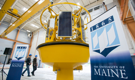
The University of Maine’s Advanced Structures and Composites Center’s latest technology, a buoy-based floating LIDAR system, to collect deepwater offshore hub-height wind and other metocean measurements in the Gulf of Maine.
Last October, UMaine’s Composites Center, NRG Systems Inc., AWS Truepower LLC, UMaine’s Physical Oceanography Group (PhOG) and Leosphere SAS established a research and development partnership to gather deepwater metocean data in the gulf. UMaine has designed a floating system to house a modified WINDCUBE® v2 Offshore LIDAR Remote Sensor, which has been adapted to a dynamic marine environment.
The floating system, which incorporates a proven LIDAR system that detects wind conditions using laser technology up to 200 meters above the ocean surface, is based on buoy technology developed and tested by UMaine’s Physical Oceanography Group over the past decade in the Gulf of Maine and abroad. AWS Truepower will conduct a campaign to validate the data collected by the floating system.
The buoy is scheduled for deployment alongside UMaine’s VolturnUS 1:8 floating offshore wind turbine, the first grid-connected offshore wind turbine in the U.S., on June 1 off the coast of Castine, Maine.
“This partnership between UMaine and our private industry leaders will advance resource assessment technology and will help propel the U.S. forward in deepwater offshore wind technology development,” says Habib Dagher, director of UMaine’s Composites Center. “Floating LIDAR technology, once fully validated, will provide us with a cost-effective method to assess the wind resource in areas traditionally off-limits to offshore wind developers.”
With funding from the Maine Technology Institute and the U.S. Department of Energy, UMaine’s Composites Center is leading this effort to enable cost-effective measurements hub-height winds in deepwater where fixed-based towers are not feasible. UMaine’s Composites Center is actively developing and testing innovative floating wind turbines for deployment in deep water.
UMaine’s Physical Oceanography Group develops and operates real-time ocean observing systems. It operates the Gulf of Maine Observatory as part of the Northeast Regional Association of Coastal and Ocean Observing Systems and the real-time buoy array of the Caribbean Integrated Ocean Observing System.
NRG Systems is an independently owned company that has served the global renewable energy industry for 30 years. Its measurement equipment, turbine health monitoring systems, and LIDAR remote sensors can be found in 150 countries on every continent, serving electric utilities, renewable energy developers, turbine manufacturers, consultants and research institutes.
AWS Truepower is one of the world’s leading providers of renewable energy solutions to developers, investors, utilities and governments.
Contact: Elizabeth Viselli, 207.581.2831
