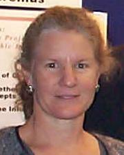
M. Kate Beard-Tisdale
Director, National Center for Geographic Information and Analysis
Research Interests
- Spatio-temporal data models
- Spatial information retrieval
- Exploratory analysis and visualization of spatio-temporal data
Research Project
New England Sustainability Consortium: Safe Beaches & Shellfish
Resources:
Presentation – Creating a Decision Support Toolbox for Safe Beaches & Shellfish (Vimeo)
Degrees:
- University of Wisconsin, Ph.D. (Geographic Information Systems)
- University of Wisconsin, M.S. (Geographic Information Systems)
- Iowa State University, B.S. (Landscape Architecture)
Courses
- SIE 509: Principles of GIS
- SIE 512: Spatial Analysis
- SIE 510: GIS Applications
Profile
Kate Beard is a faculty member at the University of Maine. She has been a research faculty with the National Center for Geographic Information and Analysis (NCGIA) since its inception in 1989, and serves as the Acting Director for NCGIA-Maine. Dr. Beard’s current research interests include modeling, analysis and visualization of spatio-temporal phenomena. She has directed and participated in many large interdisciplinary research projects. She was project director for an NSF IGERT–an interdisciplinary PhD training program in Sensor Science, Engineering and Informatics, a collaborative partnership with the Laboratory for Surface Science and Technology (LASST). She has worked closely with marine scientists and oceanographers on analysis and management of ocean observing data collected over the last decade. She served as a Senior Researcher on the Cyberinformatics Committee for the University of Maine EPSCoR Sustainability Science Initiative, a Senior Researcher on an NSF EPSCoR collaborative project with the University of New Hampshire on Advancing Sustainability Science and Knowledge-action Capacities in Coupled Coastal Systems and a Senior Researcher on the NSF EPSCoR SEANET project which investigates the social and ecological carrying capacity to advance aquaculture in Maine. She is the lead for the campus Data Science and Engineering emerging research initiative.
Beard’s research with the Mitchell Center has focused on spatial information, modeling, and a project developing on-line access to information on Maine Lakes. Her research in data management strategies was a major component of an application to a National Science Foundation grant. She was also a participant in the New England Sustainability Consortium (NEST) Safe Beaches & Shellfish project.
Her research has been funded by the National Science Foundation, National Geospatial Intelligence Agency, Office of Naval Research, U.S. Geological Survey (USGS), Battel Memorial Institute: Transportation Division, National Aeronautics and Space Administration (NASA), National Spatial Data Infrastructure Project, and the Senator George J. Mitchell Center.
Beard has been published in many peer reviewed journals including American Cartographer; Australian Surveyor; Bioinformatics; Cartography and Geographic Information Systems; Computers, Environment and Urban Systems; Information Visualization; Journal of Digital Libraries; Photogrammetric Engineering & Remote Sensing; Transactions in GIS; and URISA Journal.
Selected Publications
Meyer, S. Beard, K. Cronan, C. and Lilieholm, R. 2015. An analysis of spatio-temporal landscape patterns for protected areas in northern New England: 1900–2010. Landscape Ecology 03/2015; DOI: 10.1007/s10980-015-0184-6.
Beard, K. and Neville, M. 2014. A Place and Event Based Context Model for Environmental Monitoring. H. Huang, J. Hahn, C. Claramunt, T. Reichenbacher, (Eds). Proceedings of the 1st International Workshop on Context-Awareness in Geographic Information Services (in conjunction with GIScience 2014). pp 3-16.
C. Farah, K. Beard, C.T. Hess, and J. Hock, “Analyzing Spatial and Temporal Radon-222 Trends in Maine,” Journal of Health Physics 102, no. 2 (2012): 115–123.
K. Beard and P. Smitherman, “Creating Residential and Tenure Histories from Multi-Year White Pages,” Transactions in GIS 15, no. 6 (2011): 811–827.
K. Beard, J. Emerson, H. Deese, M. Scott, A. Rude, and N.R. Pettigrew, N.R. “Use of the EventViewer for Visualizing and Exploring Events Extracted from Ocean Observing System Data,” Marine Technology Journal 45, no. 1 (2011): 112–124.
Neal R. Pettigrew, C. Patrick Fikes, and M. Kate Beard, “Advances in the Ocean Observing System in the Gulf of Maine: Technical Capabilities and Scientific Results,” OCEANS IEEE-Sydney (2010): 1–9.
K. Beard, H. Deese, and N. R. Pettigrew, “A Framework for Visualization and Exploration of Events,” Information Visualization 7 (2008):?133–151.
M. E. Dolan, C. C. Holden, M. K. Beard, and C. J. Bult, “Genomes as Geography: Using GIS Technology to Build Interactive Genome Feature Maps,” BMC Bioinformatics 7 (2006): 416–425.
P. Agouris, K. Beard, G. Mountrakis, and A. Stefanidis, “Capturing and Modeling Geographic Object Change: A Spatio-temporal Gazetteer,” Photogrammetric Engineering & Remote Sensing LXVI, no. 10 (2000).
P. Doucette and K. Beard, “Exploring the Capability of Some GIS Surface Interpolators for DEM Gap Fill,” Photogrammetric Engineering & Remote Sensing 66, no. 7 (2000): 881–888.
B. Buttenfield and M. K. Beard, “Graphical and Geographical Components of Data Quality,” Visualization in Geographic Information Systems (1994): 150–157.
W. Mackaness and K. Beard, “Use of Graph Theory to Support Map Generalization,” Cartography and Geographic Information Systems 20, no. 4 (1993): 210–221.
Book Chapters:
K. Beard. “Modeling Change in Space and Time: An Event Based Approach, in Innovations,” in GIS: Dynamic & Mobile GIS: Investigating Change in Space and Time, eds. Jane Drummond, Rolland Billen, David Forrest, and Elsa João (Taylor & Francis, 2006), 55–74.
R. Deveillers and K. Beard. “Communication and Utilization of Information on Spatial Data Quality,” in Fundamentals of Spatial Data Quality, eds. Rodolphe Devillers and Robert Jeansoulin (2005), 275–290.
M. K. Beard. “Role of meta-information in uncertainty management,” in Spatial Uncertainty in Ecology: Implications for Remote Sensing and GIS Applications, eds. Carolyn T. Hunsaker, Michael F. Goodchild, Mark A. Friedl, and Ted J. Case (New York: Springer, 2001), 363–378.

