Monarch Model Validator
1) Download the App (iPhone) (Android) (Windows)
2) Get the Username and Password by Accepting the Terms and Conditions
3) Login and Complete a Survey
4) See below for Frequently Asked Questions

The Monarch Model Validator is an application available for Apple or Android smartphones, as well as any device running Windows 10. It is a powerful tool that will allow us, with your help, to ground-truth a model that predicts habitat suitability for monarch butterfly stopover use during the fall migration in the Atlantic Flyway, from Maine south to Georgia and from the Atlantic Ocean west to the Appalachian Mountains.
The Monarch Model Validator consists of a series of questions about the habitat at various locations across the Eastern Seaboard. In order to use it, you must download the app from the links above and then get the username and password by agreeing to the terms of use in the Disclosure & Access Information tab to the left. Once logged in to the app, select Monarch Model Validator, navigate to a predetermined survey location OR select a site of your own, press the + icon in the blue bar, and fill out the survey. You may also upload photographs of the site. More detailed instructions are available in the Monarch Model Validator User Manual to the left. Please note that this app is focused on roost sites for adult monarchs migrating during the fall, but the questions we ask are about habitat conditions so we welcome reports year round and of monarchs in any condition – adult, juvenile, or even absent!
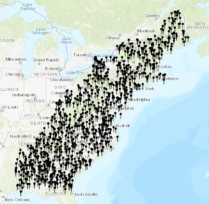
Predetermined Survey Locations
This web page provides the Terms of Use and login credentials for the Monarch Model Validator App, which is a survey within the Collector for ArcGIS app (available here for Apple, here for Android, and here for Windows). On the “Disclosure and Access Information” page, the User must agree to the Terms of Use, which will give them the guest login information to access the Collector for ArcGIS app. This web page also contains a User Manual for the app which provides step by step directions for accessing the survey, and descriptions with examples for all habitat types.
If you submit survey data (completed questionnaire) at locations identified with the app and are willing to be contacted for clarifying information, please send an e-mail to monarch-model-group@maine.edu with your preferred contact information and the point numbers that you evaluated with the questionnaire via the app.
Please direct questions about the app to monarch-model-group@maine.edu.
Thanks for your interest!
Frequently Asked Questions
1) How can I retrieve and open the app? Follow these steps:
a. On this web site on the left side of the screen, select the blue bar titled “Disclosure and Access Information”
b. Read the Disclosure and Access Information. Select the “yes” button at the bottom, and the user name and password will be revealed. Jot this down. You will need it to download the app.
c. Install the Collector for ArcGIS app on your phone by going to your app source for your phone type (see second paragraph, above in the middle of the page). Look for the Collector for ArcGIS app, which when selected, will ask you for the user name and password. Enter the username and password from step ‘b’. When you enter that, our monarch model validator map that is in our app (accessed by providing the user name and password) will be there for you to open and use. This username and password is specific for our project; when you use that to open the Collector for ArcGIS app, it will bring up our Monarch Validator Map project as the option to select.
d. Navigate to the locations represented by pins on the map within the app and complete the survey there, or you can enter the survey information for a site where you have observed monarchs. Open the survey by clicking on the + icon on the top or bottom of your phone, and then select the “Site Evaluation Survey”.
2) I don’t have a smartphone. Can I still complete the survey?
YES! You complete the survey by downloading the Collector for ArcGIS onto your PC or MAC computer from this link (https://www.microsoft.com/en-us/p/collector-for-arcgis/9wzdncrdg7lk?activetab=pivot%3Aoverviewtab) and completing the survey through that tool.
You also can request a copy of the survey questions to complete in a document that is then e-mailed back to us, with photos. Please contact us at monarch-model-group@maine.edu to request this form of the survey and instructions for completing it.
3) Where can I find out more information about using the app?
This web site provides information about the app development, purpose, and access. You can also find a user guide by clicking on the “Monarch Model Validator User Manual” bar to the left or clicking https://umaine.edu/mainecoopunit/wp-content/uploads/sites/478/2019/02/Collector-Instructions.pdf .
4) Where is the App intended to be used?
You can submit responses to the survey questions from anywhere in the US, however, currently our habitat suitability model map is focused in the eastern states generally in the area from Maine to the shores of the eastern Great Lakes and southward to Georgia. We will be working on a model that predicts roost habitat during the southward migration in the Midwest region of the US next, so if you are in that area and you would like to upload a location and response to the survey, please do.
5) It is not currently the fall migration period. Can I still use the app?
Yes. The questions the survey asks are predominately about the habitat at the location. These questions can be answered at any time of the year, not only when butterflies are present.
6) May I report a location and survey at a place that is NOT included in the pre-selected “pins” on the map?
Yes. We want to receive data reports from the randomly selected locations represented by the pins on the App map, but we also may be able to use the survey responses that you submit from other, “non-pin” sites.
7) What is the location or point ID?
You have two choices when selecting a location where you will complete the survey. You can either navigate to a pin and complete the survey there, or conduct a survey at a “non-pin” location. We can use the geolocation to figure out exactly where the survey was taken. If you zoom in on a pin, and select it, you will see that the pin has a survey number. That would be the number to put into the ID question, and you then complete the survey at that pin. But, if you want to survey a “non-pin” location, you can give that survey response a number at the ID question. If you are willing to send us that number (the ID) in an e-mail to our monarch-model-group@maine.edu mailbox, we will use it to follow up with you if we have questions about the survey you conducted.
8) I have seen monarch eggs/caterpillars/chrysalis. Would you like me to complete a survey about those observations?
Our survey questions are habitat focused and intended for reports of adult migrating monarchs and their roost locations. We also potentially can use the survey data that you submit for observations of non-adult monarchs, however, you might also consider submitting those observations to https://journeynorth.org/monarchs or https://www.inaturalist.org/. These organizations receive reports of monarchs throughout their life cycle.
9) Is there a fee for using the App?
The App is free. If you use the manual geotagging photos on your phone to take pictures where you complete a survey that is free. If you use Solocator, that is a one-time 99 cent charge. Our user guide also has step-by-step instructions for downloading and using the app.
10) How do I record locations on the photos collected where I completed a survey?
If you are going to take photos and submit those with the survey (not required but helpful if you do), instructions for that are on page 1 and 2 of the user guide (https://umaine.edu/mainecoopunit/wp-content/uploads/sites/478/2019/02/Collector-Instructions.pdf).
11) Where can I find information about the habitat types listed in the survey questions?
When you have the app open on your phone and can see the map with the pins, zoom out so that you can see the area to the west of the region with the pins. You will see icons that are the University of Maine symbol. Click on an icon. This will bring you to a verbal description of a habitat type. At the bottom of that screen you will find photos of the habitat types. Click these to display a photo and compare to your location.
Each icon illustrates a different habitat type, so explore these icon locations to get a “picture” of the types we are asking about.
You can find descriptions and example photos in the user manual, accessed from the fourth blue bar to the left or at https://umaine.edu/mainecoopunit/wp-content/uploads/sites/478/2019/02/Collector-Instructions.pdf.
12) What if I don’t see a monarch at the survey location. Do you still want the survey to be uploaded?
YES! We hope you see lots of monarchs, but even if you don’t see any monarchs at a location, we still can use the data that describes the site, to help us determine if our model is predicting suitable habitat for monarch stopover roosting. Roost sites are transient, and just because there isn’t one present now doesn’t mean there won’t be tomorrow.
13) What do you mean by “habitat suitability”?
Basically, we are looking for information about locations where there is habitat that would be used by adult monarch butterflies for roosting (stopping to rest) during their southward migration in the late summer. They need to have access to nectar sources for food (e.g., meadows, gardens, other places with lots of flowers) during this very long flight, and they need places to gather to spend the night (dead hollow trees, areas that provide shelter from bad weather but also where they can warm up in the morning). We have used information from the literature to develop a prediction of where areas that contains those habitat types might be. So, suitable habitat would contain lots of flowers for nectar sources and perhaps some trees or other structures that provide an area out of the weather and wind. Unsuitable habitat would be habitat such as open water, pavement, forest. We will use the uploaded photos and the survey question answers to help us understand the suitability answer.
(The Background section of this web page provides more information about our project ).
14) Is it OK to report the location in latitude and longitude?
Yes, whatever coordinate system your geotagging tool uses is fine. Lat and long are fine, UTM, etc.
15) What are the steps for uploading photos?
Follow these steps within the survey to upload photos you have already captured, or to take and upload the photos during the survey:
a. While you are in the survey, click on the camera icon in the blue bar at the top of the screen, next to “Submit”. This will take you to an “attachments” screen.
b. Click on the box labeled “Add”. You can either take the photos at this point (Take Photo or Video), or upload photos that you already took (Choose from library).
c. If you select “Take a photo or Video”, capture the photo, and select “use the photo” to add it to the attachments page.
d. If you select “Choose from Library”, select the photo from your library, and it will be added to the attachments page.
e. After you have taken and uploaded your photos, select done.
f. Complete the survey and select “submit”.
This web page provides the Terms of Use and login credentials for the Monarch Model Validator app, which is an ESRI Collector app for ground-truthing a model that predicts habitat suitability for monarch butterfly stopover use during the fall migration in the Atlantic Flyway. The User agrees to the Terms of Use if they use the guest login to access the ESRI Collector app. This web page also contains a User Guide to the app.
If you submit survey data (completed questionnaire) at locations identified with the app, please send an e-mail with your preferred contact information and the point numbers that you evaluated with the questionnaire via the app.
Please direct questions about the app to monarch-model-group@maine.edu.
Thanks for your interest!