Penobscot Basin Geologic History
Landscape Level
The bedrock geology and surficial geology of Maine provide the base for the Penobscot River. Rock types and characteristics, their thickness, stratigraphic relationships, and geographic distribution all effect the river’s morphological characteristics. Maine’s geologic history covers more than half a billion years and has been shaped by a variety of processes such as erosion and sedimentation, mountain-building, deformation, metamorphism, and igneous activity (Table 1) that have worked to shape the river as we know it.
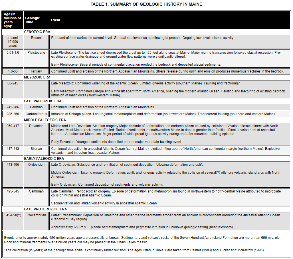
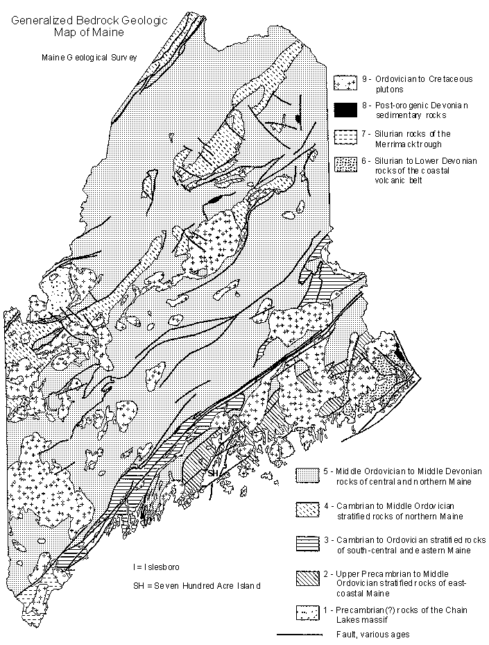
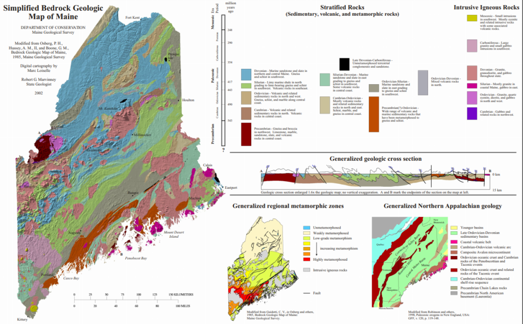
Much work into understanding Maine’s geology has been done through the years. While the geologic map produced by Osberg and others in 1985 shows hundreds of bedrock formations, they can often be summarized into nine major units (Maine Geological Survey, 2005) consisting of eight groups of stratified rocks and one group comprised of all major plutons (i.e., magma solidified at depth). The Penobscot River Basin is largely comprised of middle Ordovician to middle Devonian rocks of central and northern Maine (Marvinney, 2012). These consist of marine sandstone and slate in the northern and central regions grading to gneiss and schist in the southwest (Marvinney, 2002). Interspersed are also Cambrian to middle Ordovician stratified rocks in northern Maine consisting of volcanic and related sedimentary rocks. Mount Katahdin, nestled between the East and West branches of the Penobscot, is a Devonian aged pluton of granite, granodiorite, and gabbero.
Surficial Geology
Much of the surficial geology in Maine are products of continental glaciers that extended and retreated from about 2.5 million to 10,000 years ago. The last ice sheet expanded across Maine from the northwest about 35,000 years ago and reached its terminal position in southern New England about 21,000 years ago (Sirkin, 1986). Glaciation deposited material across the landscape, formed lakes, and disrupted drainage patterns. It also depressed the Earth’s crust, allowing the sea to extend far up the Penobscot River reaching present elevations of at least 420 feet. Following deglaciation, the Penobscot River adjusted by downcutting through glacial deposits to the bedrock. Downcutting produced many of the waterfalls and steps in the basin that allowed for waterpower and industrial development. Sea level continues to rise today.
Glacial Deposits
Unstratified – A mixture of rock ranging from boulders to sand and clay was deposited over most of Maine by ice. The material originated from pre-glacial surface deposits and bedrock that became incorporated into the base of glaciers. It is characterized by being poorly sorted, unstratified, and containing abundant angular scoured rock fragments in a binder of silt and clay.
Stratified – Meltwater flowed in channels across the surface and in the fractures of the glaciers. The material that was deposited consisted of sorted and stratified sand and gravel, reminiscent of modern river deposits and displaying rounded edges and abrasions reminiscent of water transport. As the glaciers melted, deposits were left in the form of ridges called eskers
Shoreline – As the glaciers melted, sea level began to rise and while the crust rose, it did so more slowly allowing the sea to inundate much of coastal and central Maine. As melting water reached the sea, large deltas were formed with sand and gravel. Much of the land between the present coastline and the post-glacial high sea level has been affected by wave action as shown by water features that are now above sea level.
Deep Water – When most of coastal and central Maine was below sea level, fine sediments that were transported by glaciers were deposited as marine silt and clay. They cover many areas and are often up to 200 feet thick in valleys.
Characteristics of Deposits
Alluvium – Postglacial sand, silt, and clay of the present river flood plains
Swamp deposits – Postglacial organic material (both fresh and decayed) and some silt and clay found in low areas with poor drainage including tidal marshes along the Penobscot River. The vegetation cover is usually low with few scattered trees.
Wind deposits – Glacial deposits of fine to medium sand reworked by the wind and stabilized with vegetation. They are usually found on the east side of major rivers and have good drainage.
Marine clay deposits – Glacial deposits of silt and fine sand covering dense clay from marine deposition. Exposures are usually unstable because the clay is often fully saturated with natural seepage occurring between the clay boundaries.
Sand and gravel deposits – Glacial deposits consisting of sand, gravel, and boulders with some silt and clay that were primarily deposited by meltwater streams. Generally, the deposits are a productive source of groundwater depending on their elevation and adjacency to water-saturated features. Many deposits along the Penobscot River have been modified by modern river action and high sea levels during inundation.
Glacial till deposits – Glacial deposits of poorly sorted clay, silt, sand, and gravel fragments ranging from 99% boulders to 99% clay varying in thickness up to 400 feet.
Anthropogenic Effects
River dynamics occur as natural processes by which a river migrates laterally or vertically. Though many natural processes influence the rate and magnitude of change, some forms of alteration can be accelerated by human activity. Land-use change (e.g., timber harvest, agriculture, and dam construction) can affect the rate at which rivers store and release sediment. Splash damming, in which cut logs were transported downstream to mills using dam-burst and controlled releases has similarly been linked to river and stream channel changes (Schanz and Montgomery, 2016; Collins et al, 2016; Magilligan et al., 2016).
Resources
Maine Geologic Survey: Explore Maine Geology
The Geological Society of Maine
References
Collins BD, Montgomery DR, Schanz SA, Larsen IJ (2016). Rates and mechanisms of bedrock incision and strath terrace formation in a forested catchment, Cascade Range, Washington. Geol Soc Am Bull, 128: 926–943.
Maine Geological Survey (2005). Surficial geologic history of Maine. Web: Last updated on Oct 06, 2005. https://www.maine.gov/dacf/mgs/explore/surficial/facts/surficial.htm
Magilligan, F. J., Nislow, K. H., Kynard, B. E., Hackman, A. M. (2016). Immediate changes in stream channel geomorphology, aquatic habitat, and fish assemblages following dam removal in a small upland catchment. Geomorphology, 252: 158-170.
Marvinney, R. G. (2012). Bedrock geologic history of Maine. Maine Geological Survey. Web: Last updated on Sep 24, 2012. https://www.maine.gov/dacf/mgs/explore/bedrock/facts/geol-hist.htm