East Branch Penobscot River Salmon Habitat Restoration Through Evaluation of Flow Regimes
Maine’s Penobscot River contains some of the last remaining spawning habitat in the United States for the endangered Atlantic Salmon. The WPES team is collaborating on a project led by the Penobscot Nation and sponsored by Maine Sea Grant to evaluate flow regimes affecting Atlantic salmon habitat in the East Branch of the Penobscot River, with a major focus on examining scenarios related to watershed conditions, climate, civil infrastructure, and human generated disturbances to help guide river management decision-making. WPES researchers are using historical information and hydrologic and spatial data to parameterize and calibrate a hydrologic model of the East Branch watershed to advance our understanding of the many factors affecting watershed and river conditions.
This page is expanding as the project progresses, so check back soon to read more about this important research!
Project Motivations – Ecohydrology
As this section of the page is expanded, it will add detail about how the river system and ecosystem interact, with a particular focus on the specific river conditions – flow velocities, bed substrates, water temperature – that are favorable for Atlantic salmon spawning habitat.
Historical Review
As this section of the page is expanded, it will paint the historical story of the East Branch and its watershed, beginning with traditional use of the river and landscape. Logging plays a large role in the subsequent history of the river and brings a series of increasingly impactful human interventions including construction of dams and, most notably, the 1830s Telos Cut canal project to divert outflow from Chamberlain Lake and its ~250 square mile watershed east into the Penobscot River system to drive logs to Bangor rather than north into Canada.
Hydrologic Modeling
In order to test scenarios and make predictions about river flow regimes under different conditions affected by both natural processes (e.g., precipitation patterns) and human interventions (e.g., dam operations), WPES has developed a hydrologic model of the East Branch Penobscot River watershed using the US Army Corps of Engineers Hydrologic Engineering Center Hydrologic Modeling System (HEC-HMS [external link]). This type of model is designed to represent hydrologic and hydraulic processes at the scale of watershed subbasins and river reaches over a period of time, generating runoff from precipitation and routing it into and through the river network and to the river outlet.
Hydrologic & Hydraulic Processes
Briefly, these are major processes that the model must account for:
- Runoff generation – a function of precipitation intensity and depth, losses to interception by vegetation, and losses to infiltration into the soil.
- Evapotranspiration – a function of vegetation type, temperature.
- Overland flow routing – efficiency and timing of precipitation or snowmelt runoff from the landscape into stream networks, affected by surface slope, flow path lengths, and surface roughness from vegetation or microtopography.
- Baseflow – efficiency and timing of groundwater flow into stream networks, controlled by soil saturation, hydraulic conductivity, and hydraulic head gradients.
- Storage – detention of runoff
- Channelized stream flow – timing and hydraulics of flow through stream and river channels, controlled by channel dimensions, bed roughness, water surface slope.
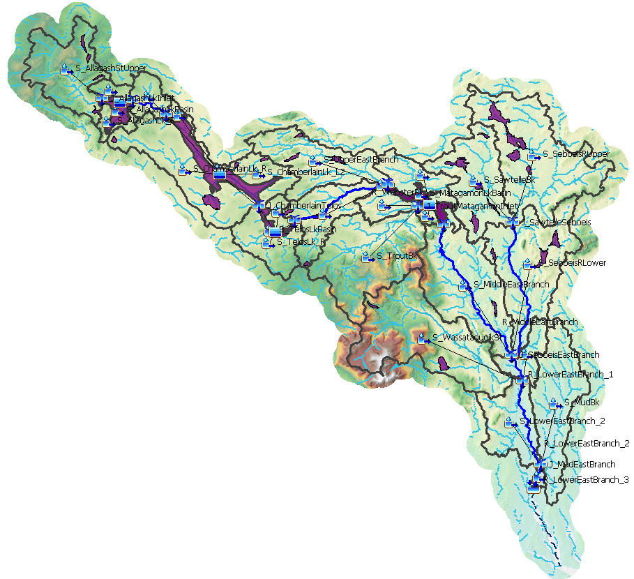
Spatial Data
The basin model for the hydrologic model is constructed using existing spatial data:
- Elevation data – used for calculations of surface slope, flow routing, overland flow lengths, subbasin delineation, and microtopographic surface storage. The East Branch model uses USGS 1/3 arc second elevation rasters reprojected to 10 meter cells.
- Stream networks – channel networks derived from USGS National Hydrography Dataset data.
- Water bodies / bathymetry – lakes and large ponds act as storage reservoirs that slowly release water. Water body surface dimensions from USGS National Hydrography Dataset and storage volumes calculated using bathymetry interpolated from lake soundings (Maine GeoLibrary).
- Land cover – used for calculations of runoff generation, evapotranspiration, canopy interception, overland flow routing. The East Branch model uses USGS National Land Cover Database (NLCD) data.
- Soils – soil characteristics control rates of infiltration (inversely related to runoff generation) and base flow, transpiration, soil percolation losses to deep groundwater, and total available soil storage. The East Branch model uses soil characteristics derived from NRCS SSURGO soils data.
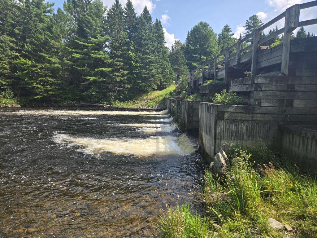
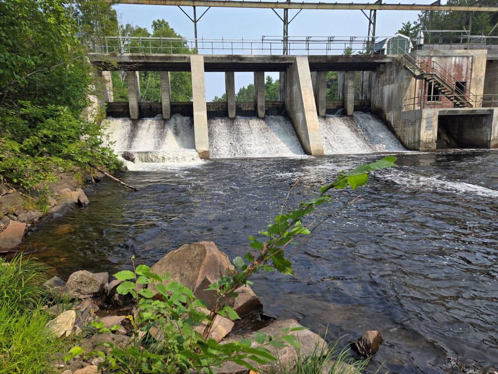
Civil Infrastructure
Two major dams controlling outflow from large reservoirs are currently represented in the hydrologic model:
- Telos Dam controls outflow from the hydrologically connected Telos and Chamberlain Lakes in the northwest of the East Branch watershed. Discharge through this dam flows east through Webster Stream and into Grand Lake Matagamon.
- Matagamon Dam controls outflow from Grand Lake Matagamon in the center of the watershed into the East Branch mainstem.
Both of these dams were modeled from dam schematics with individually controllable gates, allowing real dam operations to be included in the model as time series.
Weather & Water Cycle Time Series
- Precipitation – The source of fresh water for the model simulation. Precipitation input for the model is interpolated across the model domain using time series from multiple weather stations across north-central Maine.
- Temperature – Temperature affects evapotranspiration and snowmelt. Input for the model is interpolated across the domain using time series from multiple weather stations.
- Snowpack – Storage of precipitation during cold periods, source of additional surface runoff (beyond precipitation) during spring melt and freshet.
Calibration, Validation, & Scenario Testing
The watershed hydrologic model is calibrated using river discharge data from multiple USGS river gages, including at the model outlet in Grindstone [external link], a recently installed gage below Matagamon Dam [external link], and on the Seboeis River [external link], a tributary of the East Branch.
The validated model can be used to explore multiple scenarios, including forecasting for different precipitation inputs, investigating the effects of dam operations on modern flow regimes, and hindcasting to estimate pre-dam flow regimes.