Bringing new understanding to the Holocaust through digital humanities research
UMaine researchers leverage Geographic Information System technology to examine the spatial relationships between German occupation and genocidal actions.
The Holocaust is widely understood to have been a horrifying genocide that affected millions of people during, and long after, World War II. What may surprise some readers is that scholars continue to unearth new information and new ways to comprehend what happened under the Nazis’ brutal regime.
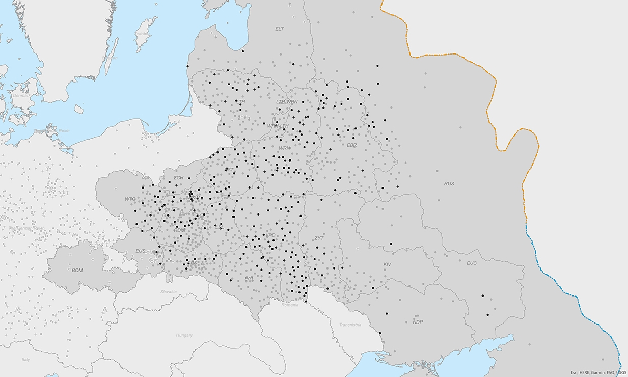
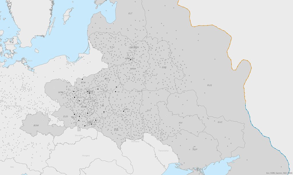
University of Maine McBride Professor of History Anne Kelly Knowles dedicated the past 16 years to revealing the geographies of the Holocaust. Mapping Holocaust sites and understanding how the nature of places influenced victims’ experiences are central concerns in her research. Her current digital humanities project, a public website, will share data on more than 2,200 camps and ghettos along with personal accounts of nearly one thousand Holocaust survivors.
Knowles is a professor in UMaine’s History Department, but she calls herself a historical geographer. Over the past 60 years, the United States witnessed a decline in university geography departments, even as Geographic Information Systems (GIS) and spatial studies in the social sciences and humanities proliferated. Some bastions of the discipline remain, but the situation has left historical geographers to feel, according to Knowles, “A bit like a unicorn in American academia.”
Historical geography focuses on the ways people perceive and shape human and physical environments across the globe. Within this field, archival research is used to discover how places differ and change over time. Maps are crucial sources for this kind of research, and making maps is an essential medium for communicating geographic understanding of the past.
Historical geography is inherently interdisciplinary. In addition, Knowles said, “Geography takes any academic study and brings it down to ground.” Seeing where events took place, or how ideas diffused across space, or the specific conditions that affected people’s lives, makes history more tangible.
Cultivating geographic awareness is all the more important today because people’s connection to place is dwindling, especially in the United States, Knowles said. “Humans living in urbanized, industrialized, and digitized societies are losing their awareness of the places where they live and how the qualities of those places, good and bad, affect them.”
By looking at historical events and focusing on their spatial qualities, Knowles hopes that her research can help people recognize changes in the environment, like poverty, pollution and injustice, and why those changes occur. “In a time when history is a disputed subject,” Knowles said, “the physical world provides really important clues to the consequences of human actions in the past.”
As a digital humanist, Knowles also sees great value in visualizing data, whether in maps, charts, diagrams, or other forms. GIS provides many of the digital tools she and her research teams use most. Bringing diverse layers of information into a common geographical space makes it possible to explore relationships in time and space. It also enables comparisons between places, regions, and nations that would be impossible to do by hand. According to Knowles, this is a key reason why the spatial turn is beginning to reshape Holocaust studies.
“GIS enables us to study just a few ghettos or hundreds. Our work is inspiring other researchers to examine the spatial relationships between German occupation and genocidal actions, like mass shootings,” said Knowles. “At the other extreme, scholars are also paying attention to how Holocaust survivors describe the places where they were sent, where they labored, and so on, to understand how physical circumstances contributed to their plight.”
Knowles and her colleagues began this work in 2008 when the Holocaust Geographies Collaborative received their first large grant from the National Science Foundation to apply historical GIS to the Holocaust. Collaborative work on this subject was a radical change for Knowles, who previously had worked as a solo archival scholar studying 19th-century immigration to the Midwest. Since coming to UMaine in 2015, Knowles has received a series of grants from The National Endowment for the Humanities Office of Digital Humanities (ODH) to build digital infrastructure and develop new modes of analysis and representation of Holocaust geographies.
Her third and most recent project funded by ODH is a public website called Placing the Holocaust. This site will weave together two ways of studying the Holocaust—mapping traits of camps and ghettos, and developing a search tool to identify and show the context of hundreds of kinds of places in Holocaust survivor testimony.
The GIS mapping side of the website holds information like how long camps and ghettos existed, the kinds of people held in such sites, incidents of disease and what type of work prisoners had to do. More than 100 variables in total have been manually entered into the camps and ghettos datasets Knowles’s teams have built. Making the data visible in maps is a crucial component of this project.
“Different parts of the brain are activated when people look at maps than when they read or solve a mathematical problem,” Knowles said. Maps can also spark new questions, particularly if they suggest previously undetected relationships. The goal of the project is to encourage and enable researchers, educators and students to understand the Holocaust in new ways, and to think about the importance of geography in the human experience.
“Memory is anchored in places,” said Knowles. “The whole project highlights that every crucial event in a Holocaust survivors’ experience was tied to some type of place. For every individual, particular places profoundly shaped their experience.”
Knowles thinks that “Placing the Holocaust” is the first digital humanities project to directly link GIS data to oral histories. The linkage is the most challenging part of the project technically, which makes it interesting for computer scientists. If the team succeeds, their work could provide a model for other large-scale GIS + linguistic projects.
The project also has significance for Holocaust scholars. “We are trying to achieve something that Holocaust scholars have been striving for since the 1990s, which is to bridge the gap between perpetrators and victims, two groups that have often been studied separately because the sources they left behind are so different,” Knowles said. “By bringing both into the same website and making it possible to go back and forth between the places where they were brought together, we hope to facilitate more integrated histories of the Holocaust.”
The final website will provide users with a unique experience, enabling them to search in various ways and, in many instances, link searches together to gain a deeper understanding of the Holocaust through the myriad places where it happened. The data and transcripts will also be downloadable, as will the maps users make as they explore the site. Not only will this provide teachers, students and scholars a new way to communicate the history of the Holocaust, but it will allow anyone to explore their own inquiry into the Holocaust through maps and testimonies.