Scientific Surveys and Results
The UMaine Deepwater Offshore Wind Test Site at Monhegan Island was established by Maine statute and assigned to the University of Maine to support research, development, and demonstration of ocean energy technology, including offshore wind and wave energy devices. The test site is located in Maine state waters, nearly 3 miles southwest of Monhegan Island and 12 miles from the mainland.
Avian and Bird Studies – Click here to download a two page overview of studies conducted at the UMaine Deepwater Offshore Wind Test Site at Monhegan Island.
5+ Years of Baseline Ecological Data Established
The University of Maine, the State of Maine, and U.S. Department of Energy have funded multiple studies/surveys to characterize the baseline physical and ecological environment of the test site.
The University of Maine closely monitored bird and bat activity at the test site from 2010 to 2014. Completed studies include partnering with the New Jersey Audubon Society to use radar to track birds and bats, vessel-based visual surveys conducted by Lubird Environmental, acoustic bat surveys conducted by Stantec, and a passive acoustic survey for songbirds at Lobster Cove, Monhegan Island, conducted by the University of Maine.
Studies Conducted
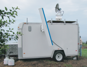
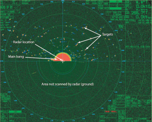
- Radar Study (New Jersey Audubon) – Click here to download the report.
- Boat Survey (Lubird Kennedy Environmental Services) – Click here to download the report.
- Acoustic Bat Survey (Stantec Consulting Inc.) – Click here to download the report.
- Passive Acoustic Avian Monitoring (University of Maine) – Click here to download the report.
- Avian & Bat Monitoring at 1:8 Scale Turbine in Castine, Maine (University of Maine) – Click here to download the report.
A full list of surveys are provided, below.
Preliminary Results
Migratory Birds and Bats
 The University of Maine has closely monitored bird and bat activity over the test site from 2010 to 2013, partnering with the New Jersey Audubon Society to maintain a radar trailer on Monhegan Island, 2-3 miles from the UMaine Deepwater Offshore Wind Test Site. Radar covered from 0-2000 meters or 0-6000 feet, and results indicated that 90% of birds fly at an altitude well above hub height.
Marine Life
 Complete studies were carried out to determine the effect of floating, offshore turbines on existing benthic (seafloor dwellers), demersal (near bottom), and pelagic (away from bottom) species. These studies included supplemented existing data available from the Maine Department of Marine Resources with physical surveys to monitor the existence and movements of marine species. Further analysis considered the impact of anchoring technologies and cabling on the benthic communities, and concluded that these species would generally move safely away from the immediate vicinity of these components during installation and removal activities. Furthermore, this assessment concluded that offshore structures serve as artificial reefs and often create an ecosystem for marine life in the area.
Completed Avian and Bat Studies Related To UMaine Deepwater Offshore Wind Test Site at Monhegan Island
Radar Study – Conducted by New Jersey Audubon
Objective: Assess movement patterns of aerial vertebrates in the vicinity of Monhegan Island
Dates: July 2010-July 2011
Effort: 361 days, 8,664 hours
Monitoring area:
- Southern Monhegan Island, Lobster Cove
- Vertical: 1 nautical mile (~1,900 m, ~6,000 ft)
- Horizontal: 1.5 nautical mile (~2,800 m, ~9,000 ft)
- Number of nocturnal targets and movement rates in comparison to other areas:
- Similar to Block Island, Rhode Island
- Similar to coastal New Jersey
- Less than half of those recorded in Cape May, New Jersey
- Lower than mid-Atlantic Appalachian Mountain region
- Lower than several terrestrial studies in the northeast and northwest U.S.
Boat Survey – Conducted by Lubird Kennedy Environmental Services
Objective: Determine bird species presence and relative abundance at the UMaine Deepwater Offshore Wind Test Site at Monhegan Island
Dates:
- Fall: Sept-Nov 2011
- Winter: Dec. 2013-May 2014
- Spring: April-June 2013
- Summer: June-August 2012
Effort: 41 surveys
Monitoring area:
- Test site quadrat and control quadrat
- 4.2 square miles (11 km2) area covered
- All birds recorded within 1,600 ft (500 m)
Most common species:
- Fall: Cormorant, hearing gull, greater shearwater, and northern gannet
- Winter: Herring gull, unidentified alcid, common eider, and razorbill
- Spring: Herring gull, northern gannets, laughing gull, great black-backed gull
- Summer: Wilson’s storm-petrels, greater shearwaters, herring gull, and great black-backed gull
Acoustic Bat Survey – Conducted by Stantec Consulting Services
Objective: Determine the bat species groups present on Monhegan Island
Dates:
- August 2011 – January 2012
- July – November 2010
- September – December 2009
- Effort: 315 nights
Monitoring area: Monhegan Island lighthouse
Most common species group:
- Eastern red bat/tri-colored bat: likely red bat
- Myotis: likely little brown bat
Passive Acoustic Avian Monitoring – Conducted by University of Maine
Objective: Record flight vocalizations made primarily by late fall nocturnal landbird migrants
Dates: October 2011
Effort: 540 hours (15 hours per night x 36 nights)
Monitoring area:
- Southern Monhegan Island, Lobster Cove
- Single microphone/recording assembly ~82 ft (25 m) above sea level
Most common species groups:
- Sparrows
- Warblers
Castine 1/8 Scale Test Turbine Avian and Bat Monitoring – Conducted by University of Maine
In addition to monitoring activity at Monhegan and the test site, wildlife monitoring was conducted on a 1/8th scale floating test turbine deployed for 14 months beginning in summer of 2013, off Dice Head in Castine, Maine. This monitoring provided data on how birds and bats respond to a floating wind turbine.
Objectives:
- Record bird interactions with University of Maine’s VolturnUS 1:8 floating offshore wind turbine with webcams
- Record changes in bat activity with acoustic monitoring
Dates:
- Webcam: June 2013 –
November 2014
Acoustic bat detectors: Dice Head Lighthouse, May-October 2013 and July-December 2014; Turbine, July-December 2014
Effort:
- Webcam: Images recorded every 15-30 seconds for the duration of deployment
- Acoustic bat detectors: Dice Head Lighthouse, 305 nights; Turbine, 154 nights
Monitoring area:
- Webcam: Air/water space of approximately 4 platform diameters in front and behind the turbine including the turbine and platform
- Acoustic bat detectors: Dice Head Lighthouse and VolturnUS turbine
Results:
- No observed bird collisions
- Double-crested cormorant perched on turbine support structure
- No birds perched on the turbine after the addition of anti-perching equipment
- Bat assemblages did not change appreciably before and after turbine deployment
- The number of bat calls per night were lower at the turbine than at Dice Head Lighthouse