Users Guide
A printable version of the BeeMapper Users Guide is available, as is a Quick Guide to using the tool.
Welcome to the BeeMapper web tool. This is a guide to the use of BeeMapper, the information it provides, and how you can use this information to make pollination management decisions.
Opening BeeMapper and Exploring Tool Features
To access the web tool, please visit the homepage at http://www.umaine.edu/beemapper.
Recommended web browsers for BeeMapper are Google Chrome, Mozilla Firefox, Safari, and Opera. BeeMapper is only compatible with Internet Explorer versions 9.0 or newer. Once at the homepage, launch BeeMapper by clicking on the image of the tool.
Now that that tool is open, let’s explore the features of the BeeMapper home screen:
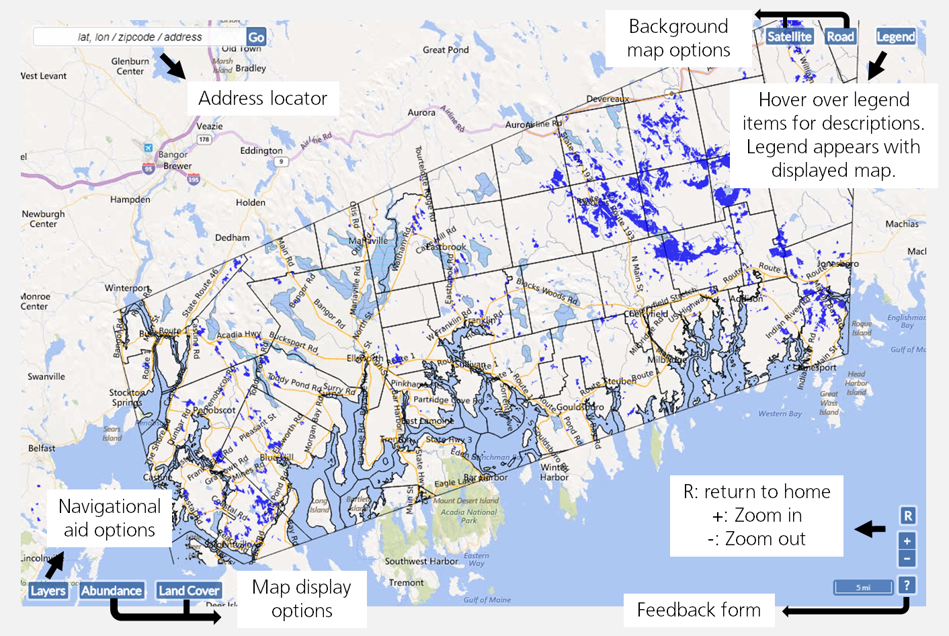
- The address locator is in the top left corner. You can use this to find your field on the map.
- You can choose between two background map options: 1) a road map or 2) a satellite image map. Choose a background map using the “Road” and “Satellite” buttons in the top right corner
- The legend button will display the legend for the current map layer. If no map layers are displayed (this is the default setting), no legend will be displayed.
- The map layer buttons are in the bottom left corner:
- Layers: this button displays a menu of maps made to help locate your field(s). You can turn these off or on any time using the check boxes next to their names. They include: roads, lakes, rivers, town boundaries, and blueberry fields.
- Land Cover: This map displays land cover, or the type of land found across the landscape.
- Abundance: this map displays the predicted wild bee abundance across the landscape.
- The tool navigation buttons in the bottom right corner allow you to zoom in (+), out (-), or return to the entire coverage of the map (R). There is also a button for a feedback form [?] to send questions, comments, or corrections back to the BeeMapper development team.
Locating a blueberry field
The first step of using BeeMapper is locating your blueberry field. There are two ways to locate a wild blueberry field:
Method 1: Use the address locator box in the top left corner. Type in the town, street address or latitude-longitude coordinates of a field, and the tool will zoom in on this location.
Method 2: Manually navigate to a field using the roads, rivers, lakes, and town boundaries provided in the tool. Place the cursor over the location of the field and scroll up to zoom in. You can also zoom in using the button in the lower right corner, then click and drag the map to the location of your field.
- To click and drag the map: Click on any area in the map and hold down the mouse. Drag the mouse across the screen, and the map will move along with it.
- If the navigational aids are creating too much clutter on the screen, they can be turned off by clicking the “Layers” button and unchecking the boxes next to the layer names.
Pollinator habitat assessment
Once you have found your blueberry field, click on it. Two shaded regions appear around your field. These represent the distance different sized wild bees can fly to access your blueberry field.
- The small circle encloses 250 yards from the edge of the blueberry field. Small wild bees can fly from within this area into your blueberry field for pollination.
- The large circle encloses 1000 yards from the edge of the blueberry field. Large wild bees, such as bumblebees, can fly from within this area into your blueberry field for pollination.
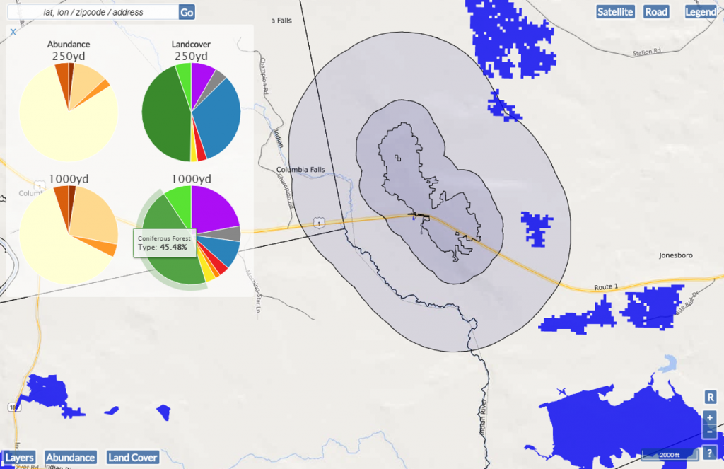 These circles are your wild bee source habitat. Wild bees that can contribute to crop pollination in your field have their nests and find forage before and after crop bloom here.
When you click on a field, a summary box with four pie charts appears in the top left corner. These pie charts summarize the land cover and predicted wild bee abundance maps for the small wild bee source habitat (250 yd) and large wild bee source habitat (1000 yd) surrounding a field. Hover over each wedge for a category label and percent total value. To close the summary box, click the X in the top left corner.
Understanding the maps
BeeMapper is based on two maps:
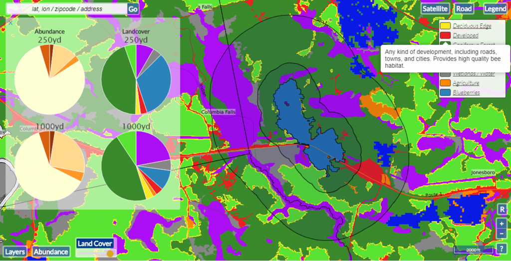
- The land cover map displays eight land cover types that each offer a unique set of habitat resources to wild bees.
- The predicted wild bee abundance map displays our prediction of wild bee abundance across the Maine wild blueberry production landscape.
- For more information on these maps, please visit the BeeMapper development page.
To display the land cover map, click the “Land Cover” button in the bottom left corner. When the map appears, a corresponding legend appears under the “Legend” button in the top right corner. Hover over each land cover type in the legend for a short description, or visit the land cover types page for a full description of each cover type. The legend can be turned off and on by clicking the “Legend” button.
To display the predicted wild bee abundance map, click the “Abundance” button in the bottom left corner. A light to dark brown shaded map appears with a corresponding legend, displaying predicted wild bee abundance across the landscape.
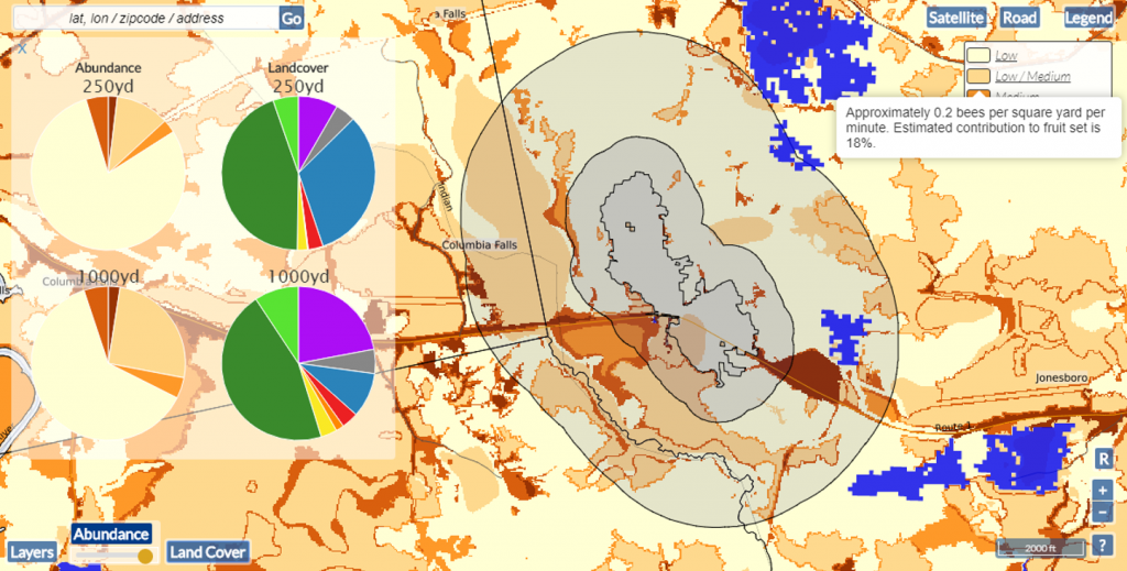
The abundance map is categorized into low, medium, or high abundance. You’ll soon notice that predicted wild bee abundance is typically low across the landscape. The predictions used to make this map are a combination of the land cover type at that spot and expert opinion on how suitable that land cover type is for wild bees. Please visit the Development page for more information on this map. The following estimates for number of bees and contribution to fruit set are based off of a large data set on wild bee density collected by Dr. Frank Drummond:
- Low: Approximately 0.1 bees per square yard per minute. Estimated contribution to fruit set is 12%.
- Low-Medium: Approximately 0.2 bees per square yard per minute. Estimated contribution to fruit set is 18%.
- Medium: Approximately 0.3 bees per square yard per minute. Estimated contribution to fruit set is 20%.
- Medium-High: Approximately 0.4 bees per square yard per minute. Estimated contribution to fruit set is 25%.
- High: Approximately 0.5-1.0 bees per square yard per minute. Estimated contribution to fruit set is 30%.
Interpreting BeeMapper information
Wild bees prefer habitat that has a variety of wildflowers for collecting pollen and nectar, ample sun exposure for warmth and easy flying, and dead wood or open, sandy soils for building nests. Using this information, experts predict that deciduous/mixed forest edge and urban/developed land cover types will provide good bee habitat. Other land cover types can provide more wildflowers (emergent wetlands, agriculture) or better nesting areas (blueberries, deciduous/mixed forest). Coniferous forest and wetlands/water provide less wild bee habitat resources than the other land cover types.
Look at the land cover map within the shaded regions surrounding your fields.
- What is the most common land cover within these buffers?
- What do you think this could mean for bees?
- Does this land cover provide high quality or poor quality bee habitat?
With this information in mind, look at the predicted wild bee abundance around your blueberry fields. Compare the abundance map to the land cover map.
- Can you see how the land cover affects the predicted wild bee abundance?
- What types of land correspond with high bee abundance? With low bee abundance?
- What is the predicted bee abundance around your blueberry fields? Why?
Making pollination management decisions
Areas with high wild bee abundance can provide up to 30% of fruit set to a nearby wild blueberry field. If these patches are found around your field, you might strategically place rented honey bee hives or purchased bumblebee quads away from these areas. You can concentrate managed pollinators in areas of your crop field that are not surrounded by high quality wild bee habitat. Additionally, conserving areas with high wild bee abundance ensures that wild bees will continue to pollinate your crop. If your crop field is surrounded by poor quality wild bee habitat with low predicted wild bee abundance, you may consider habitat enhancement to promote wild bee populations around your crop field. Additional resources on pollination management are available to further aid decision making.
Wild bee conservation
Wild bees are an important part of crop pollination and are more efficient wild blueberry pollinators than honey bees. The wild blueberry landscape can often be harsh for wild bees, but there are actions you can take to manage, promote, and conserve wild bee populations around your blueberry fields. Additional resources on wild bee conservation are available for guidance in taking these actions.
- Installing bee pasture will provide ample forage resources for wild bees. Instructions on bee pasture installation are provided by the University of Maine Cooperative Extension. To create similar resources with less effort, you may consider leaving fallow areas near your fields to flower or allowing wildflowers along field edges to bloom.
- Provide nesting resources for wild bees by installing nesting boxes for cavity nesting bees or leave open patches of sandy soil available for ground nesting bees. Allowing woody shrubs near crop fields also provides nesting resources for cavity nesting bees.
- Reduce pesticide applications, and aim to use pesticides with low toxicity to wild bees.
Limitations
The land cover map displayed in BeeMapper is based on the 2004 Maine Land Cover Dataset (MeLCD). Any change in land use since 2004 will not be accounted for in this map. In Maine, this generally means missing forest harvest, which may or may not lead to land cover change. Research in Maine is developing and ongoing as to the pollinator habitat suitability of recently harvested forest, information that may be of critical importance for wild blueberry growers.
The map is static and does not support user-generated modifications, such as the effects of installing a pollinator planting on wild bee abundance. BeeMapper provides a baseline pollinator habitat assessment for Maine wild blueberry growers to inform pollination management decisions.
We have discovered that wild bee abundance is difficult to predict accurately in blueberry fields that are small or irregularly-shaped. Model predicted bee abundance is lower, but more accurate in large, square-shaped fields with simple edges and is often overpredicted in small, elongated fields with complex edges. This does not affect predictions in other land cover types, which we have found to be accurate owing to the large amount of these other cover types in comparison to wild blueberry.
Using the BeeMapper feedback form
We welcome comments, suggestions, and corrections to BeeMapper through the feedback form, which is accessed by clicking the button with the question mark [?] in the bottom right corner of the tool window. The feedback form will appear in the top left corner of the window. All feedback goes to the BeeMapper technical development team, who will work to address any problems and answer any questions.
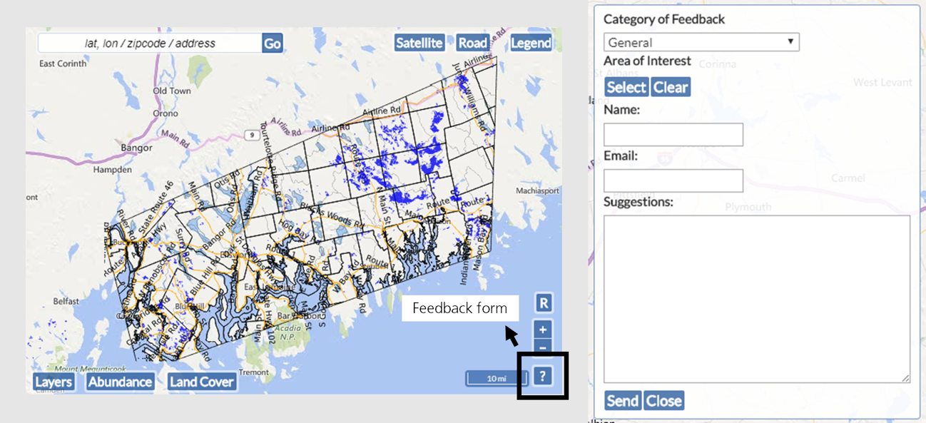
There are three categories of feedback:
- General: Any questions or comments beyond data inaccuracies or website problems can be submitted under this category.
- Map is inaccurate: If your blueberry field is not classified as blueberry in BeeMapper, please let us know through this category on the feedback form. You also can alert us to other data inaccuracies, such as an agricultural area classified as a forest, etc. Please provide a street address or lat/long coordinates so we can locate the area and make the corrections.
- You can also send us a picture of the inaccurate area using the “Area of Interest” menu on the feedback form. To do this, click “Select,” then draw the area that is incorrect. When finished, click “Done.” If you need to re-draw the area, click the “Clear” button and try again.
- Technical troubles with website: If buttons aren’t working, the maps take too long to load, or if the summary box is not displaying correctly, please let us know using this category of feedback.
Please provide your name and email address or other contact information to allow the development team to contact you with any questions. Provide feedback within the “Suggestions” box, then click “Send” to send your comments. The “Close” button will close the feedback form.