The Cold at Inuit Nunangat – A Two-Map Set
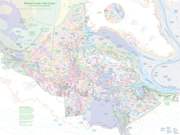

The Cold at Inuit Nunangat, by Margaret Pearce, is a two-map set with an accompanying booklet, available as flat maps or folded maps. One map, “Protecting the Cold,” portrays ways Inuit and their relatives steward the cold on Inuit homelands in Canada, and in so doing, keep the earth in balance for all beings. While the other map, “Destroying the Cold,” portrays the ways we southerners outside of Inuit Nunangat interfere with their stewardship responsibilities, and in so doing, interfere with Inuit self-determination and the balance of the earth.
Each map is digitally printed, full color, 36″ x 48″. The accompanying booklet details the many sources and acknowledgements that made this project possible.
Printed copies of this map set are available for purchase through the Canadian-American Center’s webstore.
Click the button below to purchase printed copies of the map set:
Ask the Cartographer
What questions does this project seek to answer?
What does a balanced, cold Arctic look like at Inuit Nunangat, the Inuit homelands in Canada?
Who is stewarding that balance, and what are they doing, specifically?
How is Inuit self-determination part of that stewardship?
Who is interfering with the cold at Inuit Nunangat, and what are they doing, specifically?
What effects are their actions having on Inuit Nunangat and the world?
What process did you follow?
I reached out to friends and strangers to ask for guidance and feedback. Then I reached out to Inuit organizations and research centers to propose the project, ask for feedback, and ask for permission and guidance.
At the same time, I was reading articles and watching interviews with Sheila Watt-Cloutier, Natan Obed, Mary Simon, Zacharius Kunuk, Arnait Video Productions, IsumaTV, Nunatsiaq News, and everything coming out of ITK. Then Arctic Eider Society, Ittaq Heritage & Research Centre, Oceans North, Arctic Corridors, and other research collaboratives working in Inuit Nunangat. In 2022, I had the privilege to attend ArcticNet’s Annual Scientific Meeting in Toronto, where I listened to presentations, then followed up on presenters’ publications and citations, to further my education.
Listening to these experts helped me understand who and what should be present in the map. Sometimes these data were easily available online, and sometimes they were shared with me through correspondence with an author, or for a fee as in the case of the Arctic Council’s shipping data.
Listening to these experts also helped me understand that I did not have to do original research to piece together a narrative. There is already a deluge of research in print and online. I understood it was my responsibility to read these works, listen to these speakers, then do my best to express each topic with brevity in letters and graphics. Then I reached out to those experts to ask if I’d gotten it right. So many people kindly gave their time to offer corrections and suggestions.
Design-wise, I also came to understand the work would have to be two maps, not one: one to
portray cold in balance at Inuit Nunangat, and one zoomed out to reveal the locations and actions destroying that balance. The maps must be large, to make room for detail, but not so large that they cannot be viewed in dialogue with each other on a long wall.
What’s in the map set?
Two 36-inch x 48-inch paper maps, with an accompanying booklet.
A downloadable PDF version of this map is available for use
The Canadian-American Center does not profit from the production of the “The Cold at Inuit Nunangat” map set. As such, a free, viewable PDF map is available for personal and educational use. To learn more about the downloadable version fo this map set, please clickt he button below.