New online app helps visualize, interpret spatial data on spruce budworm mitigation, forest planning
The Intelligent GeoSolutions (IGS) team at the University of Maine’s Center for Research on Sustainable Forests (CRSF) has released a free interactive mapping tool, the Forest Ecosystem Status and Trends (ForEST) app, to provide online decision support to private and public forest managers, natural resource agencies, conservation organizations and other stakeholders.
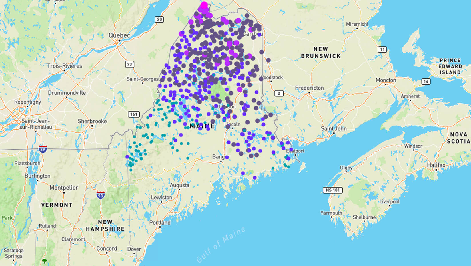
With the current outbreak of eastern spruce budworm expanding south from Quebec, up-to-date information about resource conditions and near-term risk are needed to coordinate mitigation actions in response to the outbreak and related market conditions.
The ForEST app is the culmination of three years of research and software development by the IGS team in partnership with UMaine’s Advanced Computing Group. The interdisciplinary project supported two graduate students in the School of Computing and Information Science, each of whom served as lead developer, as well as undergraduate computer science students who worked as team programmers. The interactive web interface is designed to provide near real-time information about changing forest landscape conditions resulting from the spruce budworm outbreak and ongoing management.
Current map layers include statewide pheromone trap locations with annual spruce budworm moth trap catch, and maps of forest vulnerability to budworm, percent balsam fir (primary spruce budworm host species), and areas of high probability of Canada lynx occurrence, all derived using Landsat satellite imagery and plot data from the USFS Forest Inventory and Analysis program. The mapped area (currently encompassing approximately 4 million acres of forestland) will be expanded statewide over the coming months.
ForEST utilizes a semi-automated image processing and machine learning software system known as the Supervised Adaptive Multi-objective Mapper (SAMM) developed by IGS. SAMM integrates multi-objective machine learning algorithms into semi-automated image processing and map production workflows executed on the cloud. SAMM enables efficient, high throughput processing of raw image data into high-quality output products to allow visualization and interpretation of high-resolution maps of forest and habitat conditions.
Aaron Weiskittel, professor of forest biometrics and modeling and CRSF director, emphasizes that “stakeholders can now for the first time dynamically and interactively utilize ForEST to view state-of-the-art maps of forest conditions derived from satellite imagery, explore regional budworm population monitoring data, evaluate forest risk in areas of interest, and identify natural resource management tradeoffs.” The app also offers the capacity to download GeoPDFs that allow the data to be used in the field offline.
The ForEST app creative team includes Erin Simons-Legaard, assistant research professor in forest landscape modeling; Kasey Legaard, assistant research professor of geospatial analytics and machine learning; Torsten Hahmann, associate professor of spatial informatics; and Weiskittel. Development of the Maine ForEST app was supported by the University of Maine Research Reinvestment Fund, the USDA Agricultural Research Service, and the Center for Research on Sustainable Forests.
Contact: Erin Simons-Legaard, erin.simons@maine.edu