DSRRN Restoration Resources
Diadromous Fish Species
Below is a list of the diadromous fish species of the Northwest Atlantic Ocean which includes the Canadian Maritime Provinces and the US Atlantic States. The following resource links provide information on these species.
- Sea lamprey
- Shortnose sturgeon
- Atlantic sturgeon
- Alewife
- Atlantic salmon
- Brook trout
- Rainbow smelt
- American eel
- Atlantic tomcod
- Striped bass
- Blueback herring
- American shad
Resource Links:
Restoration Resources
NOAA Conducts River Herring Stock Assessment
NOAA conducted a series of workshops in 2012 to gather more information on the status of alewife and blueback herring in the Northeast, species collectively known as river herring. NOAA worked closely with the Atlantic States Marine Fisheries Commission (ASMFC) to use information obtained in their river herring stock assessment from May 2012, along with other available information, to help make a determination as to whether these species should be listed under the Endangered Species Act. Several areas where additional information was needed included stock structure, extinction risk, and the impact of climate change on these species. NOAA held three workshops in June and July of 2012 to gather more information on each of these areas.
The Downeast Fisheries Trail
The Downeast Fisheries Trail consists of 45 locations in Hancock and Washington counties in Maine that showcase active and historic fisheries heritage sites. These sites include fish hatcheries, aquaculture facilities, fishing harbors, clam flats, processing plants, historical societies, community centers and other related places. The Downeast Fisheries Trail is part of an effort to raise awareness among residents and visitors of the importance of the region’s maritime heritage and the impact marine resources have on the area’s economy. The Trail builds on these local resources to strengthen community life and the experience of visitors.
Journal of Sustainable Watershed Science and Management (JSWSM)
JSWSM is a peer-reviewed and open access journal. It is a multi-disciplinary scientific journal that recognizes watersheds as a unit within which natural resource and environmental management issues can be addressed. It looks at integrated approaches to management involving physical, biological, socio-economical, legal and policy perspectives as they relate to sustainability. It also recognizes sustainability as a dynamic concept that accommodates all forms of change (e.g., climate, population, land use).
Atlantic Salmon General Conservation Plan
In 2009, the Gulf of Maine Distinct Population Segment (GOM DPS) of Atlantic salmon was listed as an endangered species pursuant to the Endangered Species Act (ESA). The GOM DPS was divided into three separate Salmon Habitat Recovery Units (SHRU) located in the Penobscot, Merrymeeting, and Downeast watersheds of Maine. We are planning to develop a different GCP for each of the SHRU’s.
Rainbow Smelt Website
The state governments of Maine, Massachusetts, and New Hampshire are collaborating on scientific research into the status of and threats facing the rainbow smelt, which is listed as a federal Species of Concern. The research will support development of a regional conservation and restoration plan for the species. This website is a centralized source of information on science related to the conservation of rainbow smelt in the Gulf of Maine.
The River Herring Network
The River Herring Network is a new organization, currently at the young herring fry stage of life. Although it has existed in the minds of many folks for several years, it only formally came into existence in January of 2011, with the award of a grant from the Massachusetts Bays Program to the Cape Cod Commercial Hook Fishermen’s Association. The four member project team has been meeting twice a month since May, and continues to seek review and input from a nine member Steering Committee. So far, the three main goals of the Network are to:
- Facilitate communication among herring wardens and other river herring enthusiasts
- Support herring wardens in their role as active participants in fisheries management processes
- Document and communicate the natural and cultural history of the herring runs
Canadian Rivers Institute
CRI’s goal is to advance aquatic science research and provide education on the structure and function of fresh water and estuarine ecosystems in order to improve planning, management, and sustainable use of water resources. CRI places a significant emphasis on the education and training of undergraduate and graduate students through regularly offered university courses taught by CRI Fellows and Associate Fellows. The institute offers non-credit courses for students and professionals in aquatic sciences. These courses include Freshwater Habitat, Hydrology, Stream Restoration and Design, and Biomonitoring and Environmental Assessment.
Michigan State University Quantitative Fisheries Center
The Quantitative Fisheries Center at MSU seeks to: provide a research, outreach/service, and teaching program to build greater capacity within fishery management agencies in quantitative methods; improve quantitative methods for assessing fish stocks; assist agencies in using model-based approaches in decision making; and develop a better understanding of fish community and population dynamics.
Gulf of Maine Council Ecosystem Indicator Partnership
Monitoring Map and Indicator Reporting Tool
The long-term goal of ESIP is to provide web-based access to synthesized monitoring data collected in the Gulf of Maine and its watersheds. Numerous government agencies and non-governmental organizations conduct monitoring programs in the region. The purpose of the ESIP Monitoring Map is to provide information regarding where monitoring programs exist in the Gulf of Maine. The Indicator Reporting Tool provides a wealth of data that has been collected from around the Gulf. Users can graph and map various datasets along with importing data into their preferred programs.
Maine Coastal and Aquatic Restoration Webpage
The Maine Coastal Program’s webpage focuses on the restoration of coastal and freshwater aquatic systems. Initial material on the page highlights the recently released recommendations of the Maine Stream Connectivity Work Group. Since 2009, state, federal, and non-governmental organizations participating in this group have worked to coordinate a statewide, restorative response to impaired connectivity in Maine’s waters. Subsequent additions to the Coastal and Aquatic Restoration webpage will focus on restoration project funding sources, guidance materials, and other information of relevance to restoration planners and practitioners. For more information, contact Slade Moore: slade.moore@maine.gov.
Website Launch for Viewing Global Cumulative Impact Maps
The National Center for Ecological Analysis and Synthesis has launched an interactive mapping website that shows the cumulative impact of human activities on marine ecosystems around the world. The website can be used to view maps of cumulative human impacts and each of the individual component datasets that were used to calculate cumulative impact; zoom in and out to any scale and location of interest; type in a specific lat/long and zoom to that location; produce a summary report of the results for any location; and download data for any given location.
Dam Removal and Fish Passage Network on LinkedIn
The Dam Removal & Fish Passage Network is a networking group designed to link scientists, engineers, researchers, and others working to solve issues associated with stream barriers and habitat fragmentation. The group’s goal is to share experiences and expertise relating to barrier removal and fish passage. Join here.
Global Restoration Network (GRN)
A project of the Society for Ecological Restoration International, the GRN website is an excellent resource for information on all aspects of environmental restoration, from historic ecosystems and causes of degradation, to in-depth case studies and proven restoration methods and techniques. One of the features of the website is a searchable database for environmental restoration projects located all over the world
Regional Restoration Efforts
Great Works Dam Removal on the Penobscot River
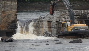 The Great Works Dam is located on the Penobscot River in Old Town and Bradley, Maine, and is owned by the Penobscot River Restoration Trust. Removal work on the dam began in early June 2012. Contractor R.F. Jordan and Sons of Ellsworth removed approximately 10,000 cubic yards of material from the river including concrete, timber and rockfill. http://www.facebook.com/PenobscotRiver
National Fish Passage Program Restoration Films in Vermont and Maine
Restoring Roads, Streams and Fish Through Improved Culverts and Flooding in Vermont
http://www.youtube.com/watch?v=5sS-owj1_kc
Multi-agency coordination leads to successful dam removal, Simkins Dam, Patapsco River, Maryland
http://gallery.usgs.gov/videos/494
Faith Fitzpatrick (U.S. Geological Survey) and Serena McClain (American Rivers, Director, River Restoration) discuss the history of how this dam removal became possible. Allen Gellis (USGS Maryland Water Science Center) discusses the importance of monitoring sediment transport related to dam removal. Matt Collins (National Oceanic and Atmospheric Administration) describes NOAA’s Fish Passage Program and how NOAA works to fund implementation and monitoring of dam removals. Graham Boardman (McCormick Taylor) discusses geomorphic monitoring and mapping, as well as sediment releases associated with dam removal.
Video on Large Woody Debris Placement on the Narraguagus River, Maine, with Project SHARE and USFWS
http://home.salmonhabitat.org/narraguagas-lwd-additions-a-video/
As a pilot project to see if this method of tree placement will hold large trees in place throughout the year, Project SHARE, DMR, and USFWS are trying to create some complexity within the river system. Large woody debris placement increases ecological diversity and creates small waterfalls, thereby increasing dissolved oxygen and cold water.
Bunker Pond Dam, Lamprey River, Epping, NH
The removal of the Bunker Pond Dam, located on the “Wild and Scenic” Lamprey River in Epping, NH, was removed in August 2011. The project took the State of New Hampshire’s Department of Environmental Services Dam Construction Crew 6 days to remove. The project was partially funded by the American Rivers/NOAA Community-based Restoration Program. Removal of the dam has opened up 27 miles of river, including tributaries in the upper Lamprey River watershed. With completion of the fishway at the Wiswall Dam anticipated in spring 2012, 70 miles of main stem and tributaries on the Lamprey River will be open to diadromous fish passage. For more information:
http://www.americanrivers.org/newsroom/blog/bgraber-20110818-northeast-dam-removals-river-life-back.html
Annapolis River in Nova Scotia
Clean Annapolis River Project, a watershed group in Nova Scotia’s Annapolis Valley, has recently completed one of the first planned dam removals in the province. The Clementsport dam was removed in early September 2011 from the lower Moose River to provide migratory fish passage. For more information: http://www.annapolisriver.ca/projects_mooseriver.php or contact Andy Sharpe.
 The Great Works Dam is located on the Penobscot River in Old Town and Bradley, Maine, and is owned by the Penobscot River Restoration Trust. Removal work on the dam began in early June 2012. Contractor R.F. Jordan and Sons of Ellsworth removed approximately 10,000 cubic yards of material from the river including concrete, timber and rockfill. http://www.facebook.com/PenobscotRiver