Ask the Climatologist: Past Questions and Answers
October 13, 2010
Question from a reader: I read about 16 inches of rain in Rhode Island and 14 inches in Nashville. The rainfall seems like pure tropical downpours, not weather like I remember. Anything to my feeling about these two weather patterns? Thank you.
– Ron Fryer
Answer: Mr. Fryer, your feeling is correct. These rainfall events were dramatically above normal for any time of year, at either location.
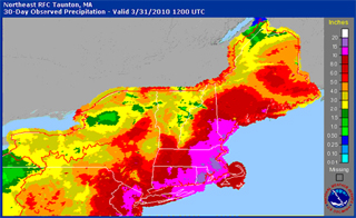
The 16-plus inches of rain in Rhode Island, as well as other locations in the Northeast, resulted from two big northeastern storms in March. The first, March 13-16, dumped six to ten inches of rain on parts of Massachusetts, Maine, New Jersey, and Rhode Island and had wind gusts exceeding 70 mph in many locations.
The second storm happened over the same area March 30-31, dumping another five to six inches of rain and making March the wettest on record for places as far apart as New York City and Portland, Maine. March was the all-time second wettest month ever for Boston with 14.87 inches of rain, behind its wettest month ever of August 1955 when 17.09 inches of rain fell with hurricanes Connie and Dianne. Providence, Rhode Island, had its wettest month ever with a rainfall total of 16.34 inches, beating the old record of 15.39 inches during a storm in October 2005. The Pawtuxet River reached a flood stage that has not been seen in over 200 years. The figure below shows total accumulated rainfall for the Northeast United States for the month of March 2010.
Even more dramatic was the rain that occurred in western Tennessee May 1-2. Rainfall amounts smashed the previous single-day records and broke May total accumulation records just two days into the month. Parts of western Tennessee received as much as 19 inches of rain. That amount of rain is not likely to fall again for 1,000 years, so it is not surprising that the National Weather Service classified this massive rainfall as an “extreme weather event,” the cause of which was a slow moving cold front from the north and a large plume of very moist air originating in the Gulf of Mexico and extending up through the Tennessee River Valley. This moist body of air contained more than twice as much water as normal.
Head of the Climate Analysis Division at the National Center on Atmospheric Research Dr. Kevin Trenberth indicates that increased temperatures may, at least in part, be responsible for such events when he said, “Global warming contributes to higher air and sea temperatures, as a result, you get increased moisture in the atmosphere and more intense rainfall events.” Whether this was an isolated event or part of a trend towards more severe weather events, only time will tell.
Thank you for your question.
– Kurt Klappenbach
April 6, 2010
Question from a reader: If the polar regions are at extremely cold temperatures, for instance, Antarctica is around -85C, how does a rise in temp of a mere 0.2C matter in terms of climatology? It seems nothing is going to thaw at those temperatures, whether they’re -85 or -84.8. Can you explain science’s concerns about such minute changes, please?
Answer from Nicole Spaulding, Ph.D. student and research assistant at the Climate Change Institute: You are correct that over much of Antarctica, air temperature is well below freezing and small increases in temperature are unlikely to cause surface melting. On the other hand, in the Antarctic Peninsula (which is surrounded by ocean) the temperatures are much higher and the increase was seen over the last 50 years (+2.5°C) has resulted in major ice loss, and Greenland (also considered a polar region) often experiences temperatures at or well above freezing.
In many cases, a small disturbance in temperature is followed by a disproportion response as the system tries to regain equilibrium. Imagine a marble at rest at the bottom of a bowl: if you push it lightly with your finger it rolls back towards the center, overshoots, rolls back, and overshoots again and again until it returns to rest at the bottom of the bowl. The movement of the marble is greater than the initial push. Even if temperatures stabilize immediately, ice sheets in Greenland and Antarctica will continue to respond to the initial disturbance, melting and adding to sea levels for decades or even centuries to come.
Now, continuing with the marble example, if we liken a drop in temperature to the push that gets the marble rolling, the marble’s role depends on a number of factors: How hard was the push (the drop in temperature)? In what direction? How big is the bowl? How steep are the sides? Just as the marble’s movement depends on these factors, the behavior of ice sheets and ice shelves is controlled by multiple factors. Sea level and ocean temperature, for instance, are as important, if not more so, than air temperature. Because ice sheets come into contact with the ocean, even small increases in ocean temperatures can cause melting at the bottom of the ice sheet. In the case of ice shelves, this melting does not add to sea level because the ice shelves are already floating (just as melting ice in a drink does not change the level of liquid in the glass), but the loss of ice shelves has been shown to increase the rates of discharge from ice streams and outlet glaciers that once were feeding the ice shelf. An excellent example of this is the glaciers feeding the now collapsed Larsen B ice shelf. Four of those glaciers experienced a two- to six-fold increase in speed at their centerlines after the shelf collapsed in 2002. Three were found to have thinned. So even a very small change in temperature can have a very large effect, and a similar ocean warming-triggered change in glacier dynamics has been predicted for Greenland.
Thank you for your question.
Nicole received her B.A. from Colgate University and a Master of Science from the University of Maine. She is in the first year of her Ph.D. program at the University of Maine.
March 15, 2010
Question from a reader: How much of an effect on ocean and air temperature does the latent heat extracted by the melting of great quantities of Arctic (Antarctic) and glacial ice have? Is this enough to have a cooling effect on local and regional temperatures here in Maine, at least while there is ice to melt?
I bring it up because we have been experiencing cooler springs on coastal Maine for the last three years, after some years of earlier springs.
Answer from Professors George Jacobson and Gordon Hamilton (glaciologist): There are a couple of questions here, so let’s answer them separately. First, the melting of glacier ice certainly does require a great amount of heat, and that transfer of energy does affect the Earth’s climate. In fact, General Circulation Models (computer models used to predict weather and climate) do include the energy-balance terms, including latent heat of ice, so these effects are definitely considered on a global scale. But it isn’t possible to tie the melting of polar ice directly to particular spring conditions on the coast of Maine.
There is, however, a relationship between Maine’s weather in the spring and the energy required for melting snow and ice in our own region. For example, snow on the ground in Maine (or ice on the Gulf of Maine) during the spring will cool the surrounding air as a result of the latent heat of fusion, i.e., the energy required to change water from solid to liquid, needs to be extracted from the atmosphere. But that effect ends as soon as the snow and ice disappear. Thus, years in which Maine has large amounts of snow lasting late into the spring might well experience slightly delayed seasonal warming.
The second part of the question involves recent spring weather. The year-to-year variability in spring conditions results from a variety of factors. We just mentioned the annual differences in late-winter snow and ice. In addition, particular configurations of the jet stream can also lead to delayed or advanced warming in one year relative to another (see the discussion elsewhere on this page). Of course, in most years the cold waters of the Gulf of Maine keep coastal areas quite cool even through June, even as the interior sections of Maine have warmed.
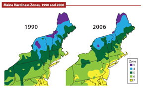
Judging whether the weather patterns of a given year or two or three are unusual is difficult because we expect high year-to-year variability. At the same time, over decades and longer, we can see trends that do have significance. For example, the map of horticultural zones in the Northeast was changed significantly between 1990 and 2006 to represent the warmer conditions that now allow many plant varieties to grow farther north than they could twenty years ago.
Finally, it is worth noting that the cool climate of coastal Maine (especially Downeast) is, in fact, influenced by cold waters coming from the far north. Most Mainers know that the extremely high tides in the eastern Gulf of Maine and the Bay of Fundy are responsible for bringing cold water to the surface twice a day. That cold water, most of which entered the Gulf of Maine through the deep Northeast Channel just south of Nova Scotia, contains water from the Labrador Sea. The cold waters in the Labrador Sea do also contain some subtropical (i.e., warmer) water that was carried around the coast of Greenland by the Irminger Current; so the temperature of that water is not determined solely by how much ice was melted in the high latitudes.
Nevertheless, the cold water that enters the Gulf of Maine and then is brought to the surface by the high tides does have the effect of keeping our coastal areas cool. The effect is lessened as the coastal current brings the water past Penobscot Bay and southward because solar energy warms it all along the way.
We welcome your climate-related questions. You will receive a response from us via e-mail. The Maine Climate News team will publish one or two of the questions we receive along with our answers in updates of Maine Climate News.